
Beacon Fell
Good walks are even better shared.
Overview
Beacon Fell: A Hiker's Delight
Nestled in the lovely Forest of Bowland, Beacon Fell stands proud at an elevation of 323 meters. This Marilyn offers not only a satisfying hike but also exceptional views that make it a favourite among local walkers.
Geology
The mountain is predominantly composed of gritstone, which is a type of sedimentary rock formed from ancient river deposits. As you ascend, take a moment to appreciate the rugged texture of the rocks underfoot and the fascinating layers that tell the story of geological history.
Walking Routes
A popular route is the Beacon Fell Country Park Loop, a comfortable 4.5 km trek through the scenic park that is perfect for families, dog walkers, and those just looking for a gentle stroll in nature. Expect to spend around 1.5 hours on this loop, making it accessible for most hikers.
Summit Features
The actual summit boasts a proud trig point that serves as a fantastic photo opportunity. It's a perfect spot to rest your weary legs and enjoy a panoramic view of the surrounding countryside. Don't forget to capture the moment for social media glory!
Terrain
Terrain-wise, Beacon Fell is grassy with some rocky outcrops, providing a blend of soft walking paths and interesting features. Just be sure to wear suitable footwear, as the paths can be a bit slippery when wet.
Views
On a clear day, the views from the summit are simply breathtaking. You can spot the impressive peaks of the Lake District and the rolling hills of the Yorkshire Dales, with the Lancashire plains sprawling below. For the best views, aim to hike in spring or early autumn—though let’s be honest, any day with sunshine will do!
Hazards
While the paths are generally safe, a few cautions stand—particularly in wet weather when paths can become slippery. Additionally, keep an eye out for livestock that may be grazing in the area; after all, we’re guests in their world.
Nearby Summits
If you're feeling ambitious, consider extending your adventure by visiting nearby summits such as Longridge Fell (365 m) and Hurst Green Hill (328 m), both of which offer their own unique viewpoints and trails.
Access
Easily accessible, the main car park is located at Beacon Fell Country Park, providing plenty of space and amenities for visitors. Public transport from towns like Longridge makes it even simpler for those without vehicles. Plus, toilets and a delightful café are available to refresh after your trek.
History
The name 'Beacon Fell' reflects its historical use as a lookout point. In times gone by, fires were lit to signal danger, offering a sense of security to those who lived below. This rich history adds a layer of depth to your visit.
Conclusion
Whether you’re an avid hiker or simply seeking a beautiful walk to escape the hustle and bustle, Beacon Fell offers a delightful experience. Just lace up those walking shoes, pack some snacks, and enjoy the beauty that this charming fell has to offer.
Explore routes near Beacon Fell
Walks starting near this hill. Open a route to check its map, distance and full itinerary.
Brockholes Reserve Tour
View route
Brockholes Wildflower Year guided walk
View route
Brockholes Reserve Tour
View route
History of Christmas guided walk
View route
Route planning notes
These notes describe possible approaches. Check a route's map and access information when planning your walk.
Beacon Fell Country Park Loop
A scenic loop that starts and finishes at the country park, offering gentle inclines and a delightful walking experience.
Make a day of it, together
Find someone to share the walk with, or organise a day out along a route you like.
Hill facts and local notes
Classifications
Elevation
267m
876 ft
Prominence
94m
Coordinates
53.8794, -2.6547
SD570427
OS Map
102
Explorer: OL41W
At the Summit
The summit features a prominent trig point and panoramic views of the surrounding countryside.
Terrain & Geology
Predominantly formed of gritstone, Beacon Fell's geology provides a fascinating insight into the past, with ancient river deposits visible in its cliffs.
Views & Scenery
From the summit, one can see the distant peaks of the Lake District, the Yorkshire Dales, and the sprawling Lancashire plains.
History & Heritage
Name Origin
The name 'Beacon Fell' suggests a historical significance of being a lookout point or marker for navigation.
Historical Significance
Historically, beacon fires were lit on the hilltops to warn of invasions and other dangers.
Getting There & Facilities
Parking
Main car park at Beacon Fell Country Park, with ample space and picnic facilities.
Public Transport
Public bus services run from nearby towns such as Longridge and Clitheroe, with stops close to the park.
Nearby Facilities
There are toilet facilities at the visitor centre, along with a café offering refreshments and snacks.
Safety Information
Known Hazards
- Wet and muddy paths can create slippery conditions, especially after rain. Watch out for livestock in the area.
General Safety Tips
- Check weather conditions before setting out
- Carry appropriate clothing and equipment
- Let someone know your planned route
- Take a map, compass, and GPS device
- Carry emergency supplies: food, water, first aid kit, torch
Hills
Some common questions about the hills answered
Are there group walks up Beacon Fell?
Many walkers use Walkmates to join or organise walks with others. You can check for group walks around Beacon Fell through the maps
Are there other walkers around Beacon Fell?
Activity varies by location and time, but Walkmates lets you see whether others have shared walks or shown interest in this area. Find other people through the walking friends search walking friends for Beacon Fell search or of course create your own walk for Beacon Fell
Can I organise a walk to Beacon Fell?
Yes. If there aren’t any walks listed already, you can create a walk and make it available for others to join.
If you're signed up to Walkmates, you can create a walk to Beacon Fell.
How do I find a walk up this hill?
There are often multiple ways to walk this hill, depending on experience and route preference. Walkmates helps you explore walks and routes that others have shared.
Can I suggest a new route up Beacon Fell?
Yes. You can suggest or create routes to share with others. Walkmates focuses on the social side of walking, so routes are used to help people organise walks and explore areas together, rather than as detailed navigation tools or route libraries.
Other uses really appreciate knowledgeable walkers sharing their routes. Share your favourite route to Beacon Fell here
The is an error or something incorrect about this hill. How do I let you know?
We always strive to keep the information on Walkmates as accurate as possible. If you find an error, please let us know through the contact form and we'll aim to correct it as quickly as possible
Community Discussion
Comments
Location
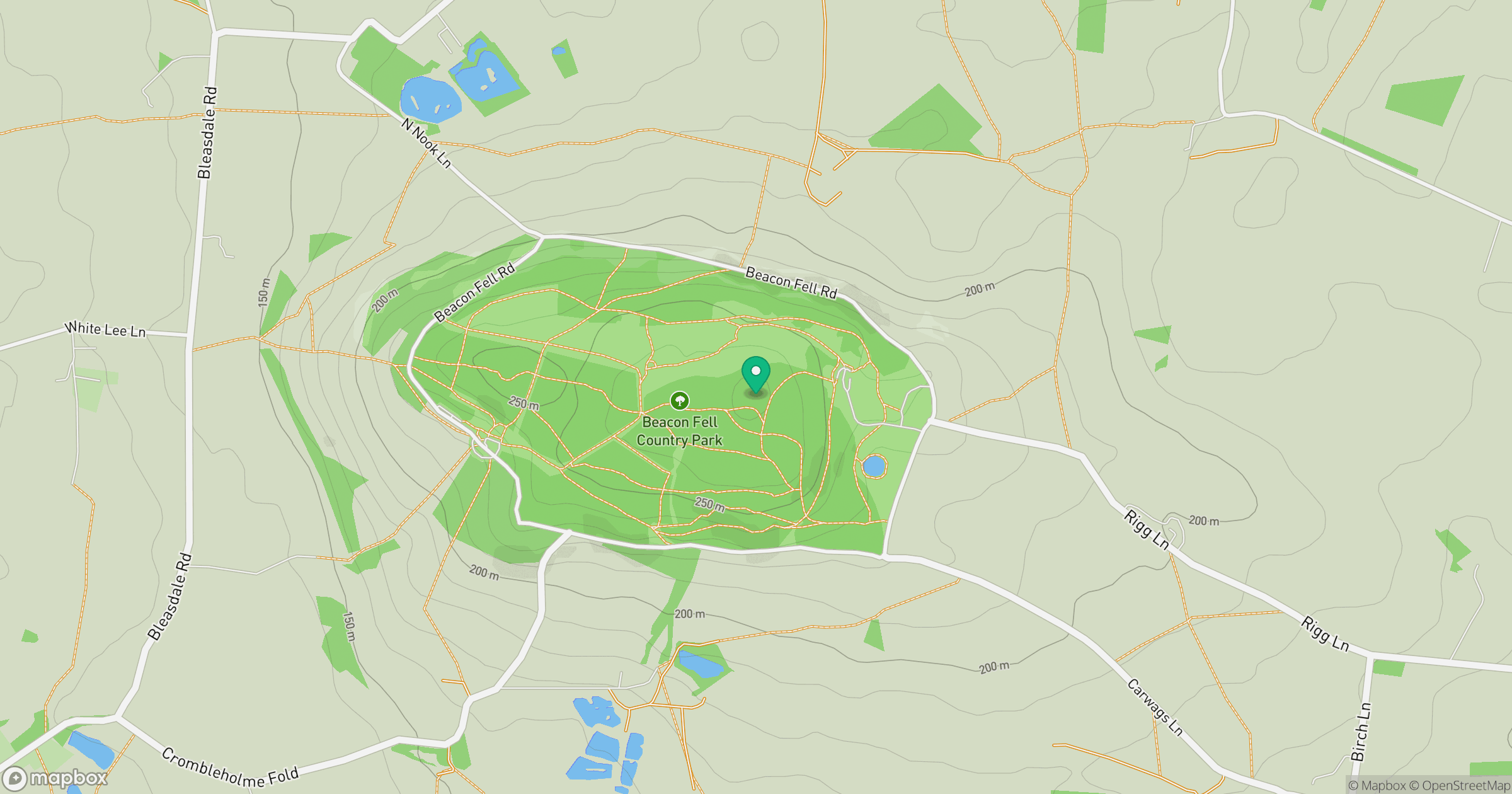
Grid reference: SD570427
View on OpenStreetMapOpens a map in a new tab, centred on the hill.




No comments yet. Be the first.