

St Agnes Beacon
Good walks are even better shared.
SW7150 : Cattle on St Agnes Beacon
Tony Atkin Photo source
Overview
St Agnes Beacon is a 192 m hill west of St Agnes on Cornwall's north coast, with 85 m of prominence. Heathland paths lead to its summit viewfinder, with wide coastal views and circular walks linking the hill with Wheal Coates and nearby coves.
St Agnes Beacon
St Agnes Beacon rises to 192 m west of St Agnes on Cornwall's north coast, with 85 m of prominence. The summit carries a viewfinder on a grassy mound. The old summit trig point was converted to a toposcope in 1998.
Landscape and history
Heather and gorse cover the open hill. The geological setting includes metamorphosed Devonian rocks, granite and much younger sand-and-clay deposits that record ancient weathering. The summit mound is interpreted as a Bronze Age barrow, later used for a warning beacon and a prospect tower.
Full return walks
The National Trust's White Rocks loop starts and finishes at St Agnes Head main car park. It visits Wheal Coates and the summit; the published full-loop distance is 4.48 km, with a two-hour estimate.
The South West Coast Path Association's Beacon on the Coast circuit starts and finishes at Trelawney Road car park in St Agnes. Its 10.1 km itinerary visits the summit, Chapel Porth, Wheal Coates and Trevaunance Cove before returning through the village.
Planning and safety
Use the matching route's named car park and follow current parking signs. Services 87/87A and 315 serve St Agnes; check current timetables for the return. The walks include uneven paths, steep sections and roads. Coastal paths pass cliff edges, and the exposed hill can be windy. A visit onto Chapel Porth beach adds a tidal hazard; neither circuit requires crossing the beach.
Explore routes near St Agnes Beacon
Walks starting near this hill. Open a route to check its map, distance and full itinerary.
Tehidy lakes, Kennels Hill and North Cliffs woodland circuit
View route
Stithians Lake circular walk: dam, woodland and Penmarth
View route
Trelissick and Roundwood Quay: Fal estuary woodland circuit
View route
Falmouth Walk with Men Walking & Talking
View route
Route planning notes
These notes describe possible approaches. Check a route's map and access information when planning your walk.
White Rocks to St Agnes Beacon loop via Wheal Coates
National Trust circuit from and back to St Agnes Head main car park (SW699513). Follow the coast path south to Towanroath engine house, climb back through Wheal Coates, then go through its car park and briefly along the road to Beacon Cottage Farm. Cross the farmyard and field, use the stone stile and climb to the Beacon summit. Descend northwest, cross the road and follow the opposite lane, then turn left beyond the sentry box and follow the heath-edge path back to the car park. The published distance and two-hour estimate cover the whole loop. Narrow, rough paths, steep climbs, stone stiles and a short road section require care; paths can be muddy.
Beacon on the Coast: St Agnes, Chapel Porth and Trevaunance circuit
South West Coast Path Association circuit from Trelawney Road car park in St Agnes (SW719504, TR5 0TP). Follow Vicarage Road and Goonvrea Road, then paths and a lane to the Beacon summit. Descend to Chapel Combe and Chapel Porth, then follow the coast path past Wheal Coates, around St Agnes Head and Newdowns Head to Trevaunance Cove. Return inland via Stippy Stappy and Churchtown to the starting car park. The 10.1 km distance covers this full return circuit. There are several climbs, coast paths, tracks and surfaced lanes; watch for traffic on the road inland from Trevaunance. Beach walking is not required.
Make a day of it, together
Find someone to share the walk with, or organise a day out along a route you like.
Photo Gallery
View all Photo could not load
SW7150 : Cattle on St Agnes Beacon
Tony Atkin
 Photo could not load
SW7050 : On St Agnes Beacon - View towards St Ives
Colin Park
 Photo could not load
SW7150 : Fresh water header tank for St Agnes and area water supply
Pete Cruse
 Photo could not load
SW7150 : Pasture, St Agnes
Andrew Smith
 Photo could not load
SW7150 : A shelter, housing a metal box, leading down from St Agnes Beacon
Pete Cruse
 Photo could not load
SW7050 : St Agnes Beacon
Gary Rogers
 Photo could not load
SW7050 : Looking North West from St Agnes Beacon
David Gearing
 Photo could not load
SW7150 : National Trust marker plate for St Agnes Beacon, with a path leading up the hill
Pete Cruse
 Photo could not load
SW7150 : Rain - Clearing
Tony Atkin

SW7150 : GPS Reference Station on St Agnes Beacon
Tony Atkin
Hill facts and local notes
Classifications
Elevation
192m
630 ft
Prominence
85m
Coordinates
50.3073, -5.2173
SW710502
OS Map
203
Explorer: 104
At the Summit
A stone-clad toposcope/viewfinder stands on the grassy summit mound. Historic England interprets the mound as a Bronze Age barrow; the summit trig point was converted to a toposcope in 1998.
Terrain & Geology
The Beacon lies in a complex setting of metamorphosed Devonian rocks and the St Agnes granite intrusion. Nearby sand-and-clay deposits preserve evidence of ancient warm-climate weathering: BGS distinguishes a mid-Oligocene Beacon Cottage Farm outlier from the Miocene St Agnes Beacon outlier. Mineral-rich veins associated with the granite helped support the local tin and copper mining industry.
Views & Scenery
Wide views extend over the Atlantic coast towards Godrevy and St Ives Bay, and along the coast towards Perranporth. Visibility depends on weather.
History & Heritage
Name Origin
The Beacon part of the name reflects its historic use for signal fires. The earliest confirmed record of this beacon dates from the early 1700s.
Historical Significance
The summit mound is interpreted as a Bronze Age bowl barrow, later used for a fire beacon and a late-18th-century prospect tower. Collapsed tower material altered its shape. Beacon use is documented from the early 1700s; a connection with the Spanish Armada is possible rather than confirmed.
Getting There & Facilities
Parking
For the National Trust White Rocks loop, use St Agnes Head main car park off Beacon Drive (route start SW699513; TR5 0NU covers the wider area). Follow National Trust signs; the car park has a 2.3 m vehicle-height restriction. For the village-based Beacon on the Coast circuit, use Trelawney Road car park, St Agnes, TR5 0TP (SW719504): a parish-managed long-stay pay-and-display car park, open 24 hours with no height restriction. Follow the current on-site tariff and ticket instructions.
Public Transport
Go Cornwall Bus services 87/87A link St Agnes with Truro and Newquay; use the St Agnes Institute stop for the village-based walk. Hopleys Coaches service 315 links St Agnes and Redruth. Check current Transport for Cornwall timetables and service updates for your travel date, including the return journey.
Nearby Facilities
St Agnes village has cafes and pubs. The village route starts beside public toilets at Trelawney Road; there are also toilets and refreshments at Chapel Porth and Trevaunance Cove.
Safety Information
Known Hazards
- Coastal sections have cliff-edge drops; keep back from edges and follow signed paths and diversions.
- Uneven paths, steep climbs and stone stiles can be awkward or slippery when wet.
- The open hill and coast are exposed to strong wind.
- The described circuits include road sections; watch for traffic, especially inland from Trevaunance Cove.
- If visiting Chapel Porth beach, watch the rising tide: it can cut off access. Neither summit circuit requires a beach crossing.
General Safety Tips
- Check weather conditions before setting out
- Carry appropriate clothing and equipment
- Let someone know your planned route
- Take a map, compass, and GPS device
- Carry emergency supplies: food, water, first aid kit, torch
Hills
Some common questions about the hills answered
Are there group walks up St Agnes Beacon?
Many walkers use Walkmates to join or organise walks with others. You can check for group walks around St Agnes Beacon through the maps
Are there other walkers around St Agnes Beacon?
Activity varies by location and time, but Walkmates lets you see whether others have shared walks or shown interest in this area. Find other people through the walking friends search walking friends for St Agnes Beacon search or of course create your own walk for St Agnes Beacon
Can I organise a walk to St Agnes Beacon?
Yes. If there aren’t any walks listed already, you can create a walk and make it available for others to join.
If you're signed up to Walkmates, you can create a walk to St Agnes Beacon.
How do I find a walk up this hill?
There are often multiple ways to walk this hill, depending on experience and route preference. Walkmates helps you explore walks and routes that others have shared.
Can I suggest a new route up St Agnes Beacon?
Yes. You can suggest or create routes to share with others. Walkmates focuses on the social side of walking, so routes are used to help people organise walks and explore areas together, rather than as detailed navigation tools or route libraries.
Other uses really appreciate knowledgeable walkers sharing their routes. Share your favourite route to St Agnes Beacon here
The is an error or something incorrect about this hill. How do I let you know?
We always strive to keep the information on Walkmates as accurate as possible. If you find an error, please let us know through the contact form and we'll aim to correct it as quickly as possible
Community Discussion
Comments
Location
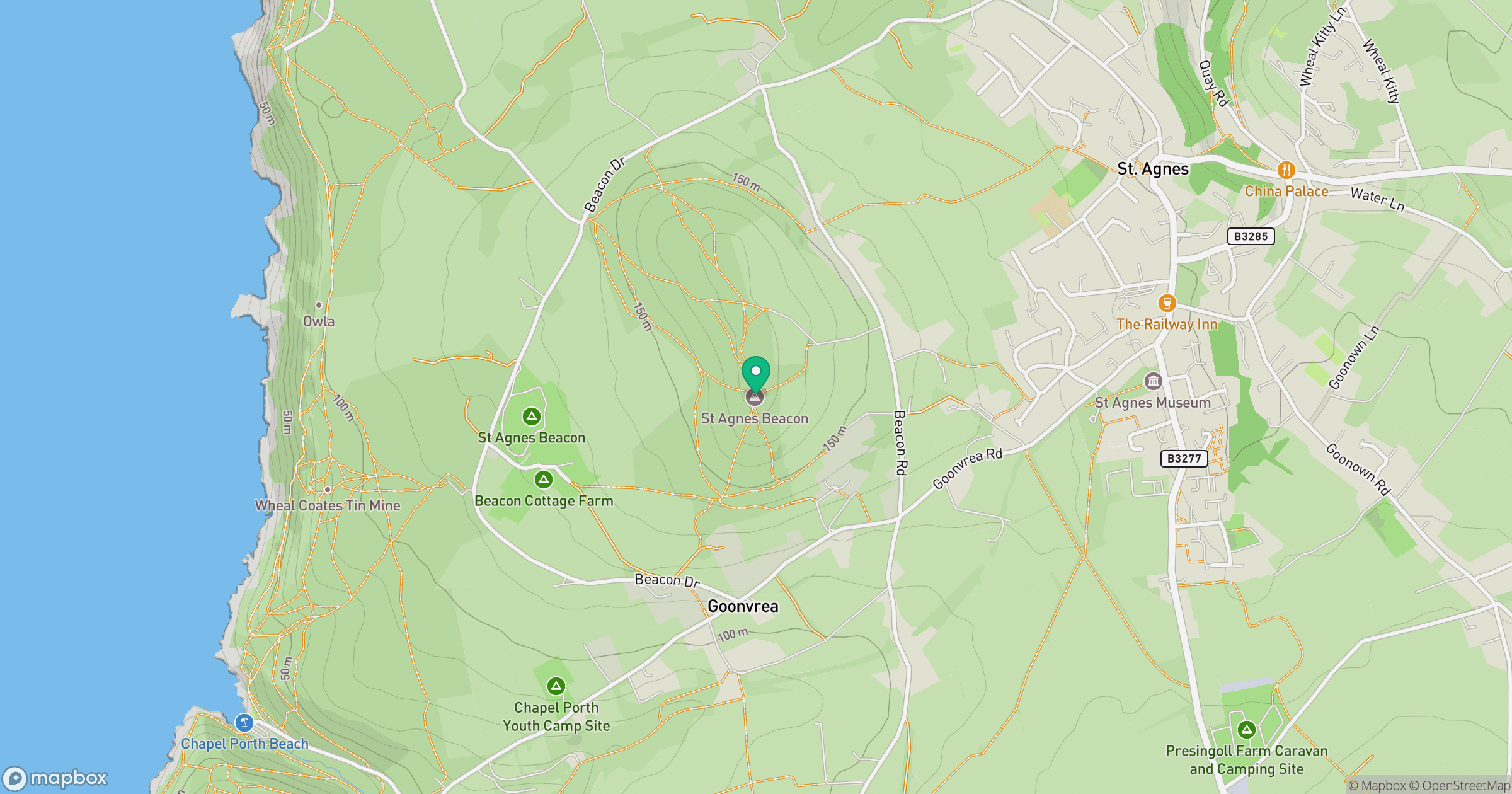
Grid reference: SW710502
View on OpenStreetMapOpens a map in a new tab, centred on the hill.
No comments yet. Be the first.