
Neath Abbey Craig
Good walks are even better shared.
Overview
Neath Abbey Craig
Neath Abbey Craig rises to about 150 meters above sea level, offering a quaint, yet fulfilling hiking experience for enthusiasts of all abilities. The trail to reach the summit can be a little tricky at times but worry not - it’s not as daunting as trying to parallel park in a busy city!
Geology
Rocky at its core, this hillside is primarily formed of Old Red Sandstone, a treat for any geology buffs. The severe cliffs provide an exciting habitat for a variety of wildlife and serve as picturesque backdrops for photography enthusiasts.
Access
Accessible from the nearest parking at the Neath Abbey ruins, reaching the start of the hike is a breeze. Using public transport? A short stroll from the Neath bus station will have you hitting the trails in no time.
Facilities
After you're back from your revelry in nature, Neath town centre has cafes galore, perfect for refueling with a delightful brew. Facilities like public toilets can be found near the abbey ruins.
Routes
The 'Neath to Abbey Trail' offers a blend of woodland strolls and scenic cliffside paths. At approximately 5 km, it’s a moderate trek that promises stunning views along the way.
Safety and Hazards
Always keep an eye on the weather forecast—British skies can get moody faster than you can say 'tea time.' Trekkers should be wary of loose rocks and steep drops, so tread lightly and bring a friend unless you fancy a one-person show.
Conclusion
All in all, Neath Abbey Craig boasts a rich tapestry of scenic beauty, geology, and history, making it a perfect destination for a day out in the great Welsh outdoors. And don’t forget—if you meet a local, they might just share their best spots for tea!
Enjoy your adventure!
Explore routes near Neath Abbey Craig
Walks starting near this hill. Open a route to check its map, distance and full itinerary.
Swansea Canal: Coed Gwilym Park to Pontardawe Aqueduct
View route
Swansea Clyne Valley Railway Walk: Blackpill to Dunvant
View route
Ammanford Walk with Men Walking & Talking
View route
Llanelli warden-led wildlife walk
View route
Route planning notes
These notes describe possible approaches. Check a route's map and access information when planning your walk.
Neath to Abbey Trail
A scenic route starting from Neath, leading you up through woodlands and along the cliffs for stunning views of the Neath Valley.
Make a day of it, together
Find someone to share the walk with, or organise a day out along a route you like.
Hill facts and local notes
Classifications
Elevation
102m
335 ft
Prominence
44m
Coordinates
51.6648, -3.8357
SS731978
OS Map
170
Explorer: 165
At the Summit
At the summit, hikers will find a modest stone cairn and a few weathered benches - perfect for a sit-down break, a cup of tea, or a moment of reflection (and perhaps contemplating life’s bigger questions).
Terrain & Geology
Primarily composed of Old Red Sandstone, Neath Abbey Craig features striking cliffs that make for both dramatic landscapes and interesting rock formations for geology enthusiasts. The site is rich in both history and geology, showcasing layers that tell the tale of ancient river systems.
Views & Scenery
From the summit, one can enjoy panoramic views of the Neath Valley, the distant Brecon Beacons, and on a clear day, the shimmering Carmarthen Bay. Keep your eyes peeled for a cheeky buzzard soaring above.
History & Heritage
Name Origin
The 'Neath Abbey' name references the nearby Cistercian abbey founded in 1130, while 'Craig' translates to 'rock' in Welsh, highlighting the rocky terrain.
Historical Significance
The area holds historical significance as a site of ancient human activity and is close to the Neath Abbey, which played a key role in the monastic history of South Wales.
Getting There & Facilities
Parking
There is parking available at Neath Abbey ruins, making it a convenient starting point for the trek up the Craig.
Public Transport
Regular bus services run from Swansea to Neath, with a short walk from the bus station to the trailhead.
Nearby Facilities
Neath town centre offers a variety of cafes and restaurants. Public toilets are also available near the Neath Abbey ruins.
Safety Information
Known Hazards
- Be cautious of loose rocks and steep drop-offs near the cliffs. Weather conditions can change rapidly, so pack your raincoat and keep an eye on the forecast!
General Safety Tips
- Check weather conditions before setting out
- Carry appropriate clothing and equipment
- Let someone know your planned route
- Take a map, compass, and GPS device
- Carry emergency supplies: food, water, first aid kit, torch
Hills
Some common questions about the hills answered
Are there group walks up Neath Abbey Craig?
Many walkers use Walkmates to join or organise walks with others. You can check for group walks around Neath Abbey Craig through the maps
Are there other walkers around Neath Abbey Craig?
Activity varies by location and time, but Walkmates lets you see whether others have shared walks or shown interest in this area. Find other people through the walking friends search walking friends for Neath Abbey Craig search or of course create your own walk for Neath Abbey Craig
Can I organise a walk to Neath Abbey Craig?
Yes. If there aren’t any walks listed already, you can create a walk and make it available for others to join.
If you're signed up to Walkmates, you can create a walk to Neath Abbey Craig.
How do I find a walk up this hill?
There are often multiple ways to walk this hill, depending on experience and route preference. Walkmates helps you explore walks and routes that others have shared.
Can I suggest a new route up Neath Abbey Craig?
Yes. You can suggest or create routes to share with others. Walkmates focuses on the social side of walking, so routes are used to help people organise walks and explore areas together, rather than as detailed navigation tools or route libraries.
Other uses really appreciate knowledgeable walkers sharing their routes. Share your favourite route to Neath Abbey Craig here
The is an error or something incorrect about this hill. How do I let you know?
We always strive to keep the information on Walkmates as accurate as possible. If you find an error, please let us know through the contact form and we'll aim to correct it as quickly as possible
Community Discussion
Comments
Location
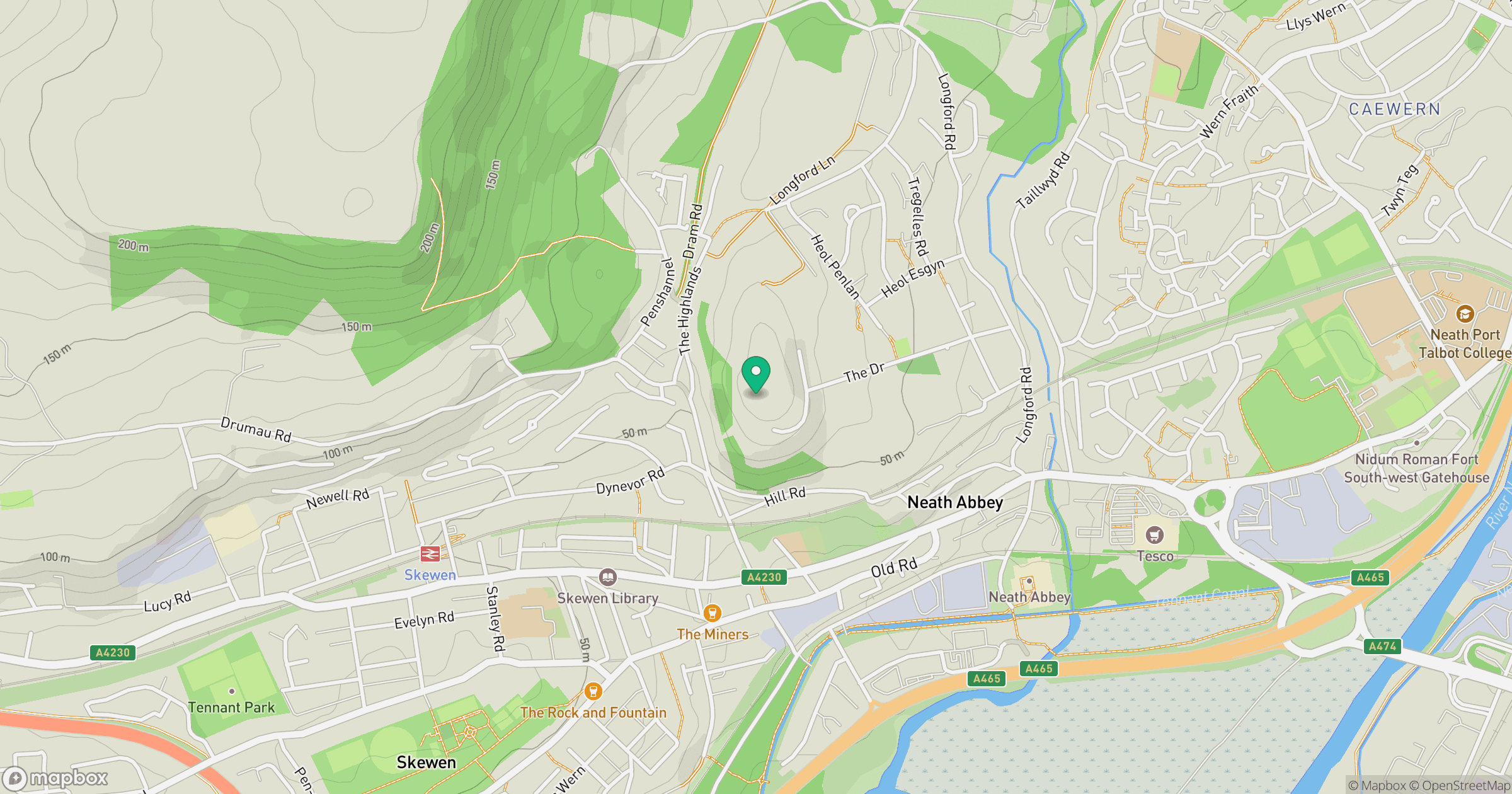
Grid reference: SS731978
View on OpenStreetMapOpens a map in a new tab, centred on the hill.
No comments yet. Be the first.