

Knock of Crieff
Good walks are even better shared.
NN8723 : Knock of Crieff
Rude Health Photo source
Overview
Knock of Crieff is a wooded Marilyn above Crieff in Perth and Kinross, with a surveyed summit of 279.2 m. Paths link the lower western viewpoint with the higher eastern summit and longer returning circuits.
Knock of Crieff
Knock of Crieff is the wooded Marilyn above Crieff in Perth and Kinross. Its surveyed height is 279.2 m. The natural high point at NN873234 is an earth mound 6 m east-northeast of the cairn; the cairn is 0.3 m lower. The viewpoint indicator on the western top, about 244 m high, is separate from the higher eastern summit.
A complete circular walk
Start at the middle Knock car park behind Crieff Hydro. The clockwise circuit visits the western viewpoint and true summit, then continues through Ferntower and Colony Farm, around the north of Callum’s Hill and beside Crieff Golf Club. Return uphill on Ferntower Road and the path beside the Hydro access road to the same car park. Scotland Off the Beaten Track publishes 6 km, 200 m total ascent and 2 hours for this whole circuit. Those figures do not describe a short summit out-and-back or a walk starting in the town centre.
Terrain and views
Woodland paths lead to heathery open ground, with some steep, narrow, uneven and muddy sections. The circuit also uses tracks, pavements and a minor road. From the open viewpoints, look across Strathearn to the Ochil Hills and towards Ben Chonzie, Ben Vorlich and Stùc a’ Chròin. Trees and visibility can limit the outlook.
Geology and history
Resistant conglomerate, formed from ancient river shingle and related deposits, helps the Knock stand above its surroundings. The SNH/BGS geology account places these rocks in the Devonian desert-river landscape. The council’s forest plan traces Knock through the Scots word for a hillock to Gaelic cnoc, meaning hill. It records woodland on the 1783 military maps and identifies the Cradle Stone and the western viewpoint indicator as features of interest.
Access and care
Reach the car park by the minor road behind Crieff Hydro, approached from Ferntower Road. Stagecoach’s 15/15A network serves Crieff; consult the current operator timetable. Benches are available at the western viewpoint. Check the council’s current Crieff toilet listings and opening times before setting out.
The full circuit crosses the A85 twice, where traffic can be fast. Keep to walking paths at mountain-bike junctions, give other path users room and follow any local forestry or access notices. Wear footwear with grip, check the forecast and allow time to finish before dark.
Explore routes near Knock of Crieff
Walks starting near this hill. Open a route to check its map, distance and full itinerary.
Crieff: Lady Mary's Walk and the River Earn
View route
Club outing: Crianlarich and West Highland Way (coach departure)
View route
Club outing: Glen Ogle and Killin (coach departure)
View route
Kenmore: Drummond Hill Black Rock Trail above Loch Tay
View route
Route planning notes
These notes describe possible approaches. Check a route's map and access information when planning your walk.
Knock of Crieff and Callum's Hill circuit
Clockwise circuit from and back to the middle Knock car park behind Crieff Hydro (NN864226). Climb to the western viewpoint, then follow the ridge to the higher eastern summit. Continue beyond the summit, avoiding the mountain-bike descent, and turn left down to the main track. Follow it towards Ferntower. Beyond the millennium cairn, take the left track and then the left footpath beside the golf course to the A85. Cross carefully, use the pavement briefly, then follow Highlandman Loan past Colony Farm. Turn onto the signed route around the north of Callum’s Hill and continue through woodland and the housing lane to the A85. Cross carefully again at the golf-club approach, follow the path beside the clubhouse, and return uphill via Ferntower Road and the path beside the Hydro access road to the same car park. Scotland Off the Beaten Track gives 6 km, 200 m total ascent and 2 hours for the full circuit. Expect steep, narrow and muddy stretches and two A85 crossings.
Make a day of it, together
Find someone to share the walk with, or organise a day out along a route you like.
Photo Gallery
View all Photo could not load
NN8723 : Knock of Crieff
Rude Health
 Photo could not load
NN8723 : Knock of Crieff Summit
Scott Cormie
 Photo could not load
NN8723 : Cairn and path at the top of Knock of Crieff
Steven Brown
Hill facts and local notes
Classifications
Elevation
279m
916 ft
Prominence
163m
Coordinates
56.3894, -3.8270
NN873234
OS Map
52 58
Explorer: OL47E 368E
At the Summit
The surveyed high point is an earth mound 6 m east-northeast of the cairn at NN873234, at 279.2 m. The cairn is 0.3 m lower. The viewpoint indicator and benches are on the lower western top, about 244 m, separate from the true summit.
Terrain & Geology
Resistant conglomerate formed from ancient river shingle and related deposits helps form Knock of Crieff. The Scottish Natural Heritage and British Geological Survey account places these rocks in the Devonian desert-river landscape.
Views & Scenery
Open viewpoints look across Strathearn towards the Ochil Hills and to Highland hills including Ben Chonzie, Ben Vorlich and Stùc a’ Chròin. Trees and visibility affect the outlook.
History & Heritage
Name Origin
Knock comes through the Scots word for a hillock from Gaelic cnoc, meaning hill.
Historical Significance
The council’s forest plan records woodland on the 1783 military maps. It identifies the Cradle Stone, a large split boulder, and the western viewpoint indicator as features of interest on the Knock.
Getting There & Facilities
Parking
The middle Knock car park on the minor road behind Crieff Hydro, approached from Ferntower Road. Scotland Off the Beaten Track gives NN864226 for the start/finish of its circuit. Follow current parking signs and leave entrances clear.
Public Transport
Stagecoach’s 15/15A network serves Crieff and connects with Perth, Comrie and Stirling. The published circuit can also be joined from the A85 near Crieff Golf Club. Check current stops and the operator timetable before travelling.
Nearby Facilities
There are benches beside the western viewpoint. Check Perth and Kinross Council’s current Crieff toilet listings and opening times before setting out.
Safety Information
Known Hazards
- The full circuit crosses the A85 twice; traffic can be fast, so cross with care.
- Some woodland and summit paths are steep, narrow, uneven or muddy. Use footwear with grip.
- Watch for cyclists at mountain-bike junctions and stay on the walking route. Follow any local forestry or access notices.
- Check the forecast and allow enough daylight for the complete return.
General Safety Tips
- Check weather conditions before setting out
- Carry appropriate clothing and equipment
- Let someone know your planned route
- Take a map, compass, and GPS device
- Carry emergency supplies: food, water, first aid kit, torch
Hills
Some common questions about the hills answered
Are there group walks up Knock of Crieff?
Many walkers use Walkmates to join or organise walks with others. You can check for group walks around Knock of Crieff through the maps
Are there other walkers around Knock of Crieff?
Activity varies by location and time, but Walkmates lets you see whether others have shared walks or shown interest in this area. Find other people through the walking friends search walking friends for Knock of Crieff search or of course create your own walk for Knock of Crieff
Can I organise a walk to Knock of Crieff?
Yes. If there aren’t any walks listed already, you can create a walk and make it available for others to join.
If you're signed up to Walkmates, you can create a walk to Knock of Crieff.
How do I find a walk up this hill?
There are often multiple ways to walk this hill, depending on experience and route preference. Walkmates helps you explore walks and routes that others have shared.
Can I suggest a new route up Knock of Crieff?
Yes. You can suggest or create routes to share with others. Walkmates focuses on the social side of walking, so routes are used to help people organise walks and explore areas together, rather than as detailed navigation tools or route libraries.
Other uses really appreciate knowledgeable walkers sharing their routes. Share your favourite route to Knock of Crieff here
The is an error or something incorrect about this hill. How do I let you know?
We always strive to keep the information on Walkmates as accurate as possible. If you find an error, please let us know through the contact form and we'll aim to correct it as quickly as possible
Community Discussion
Comments
Location
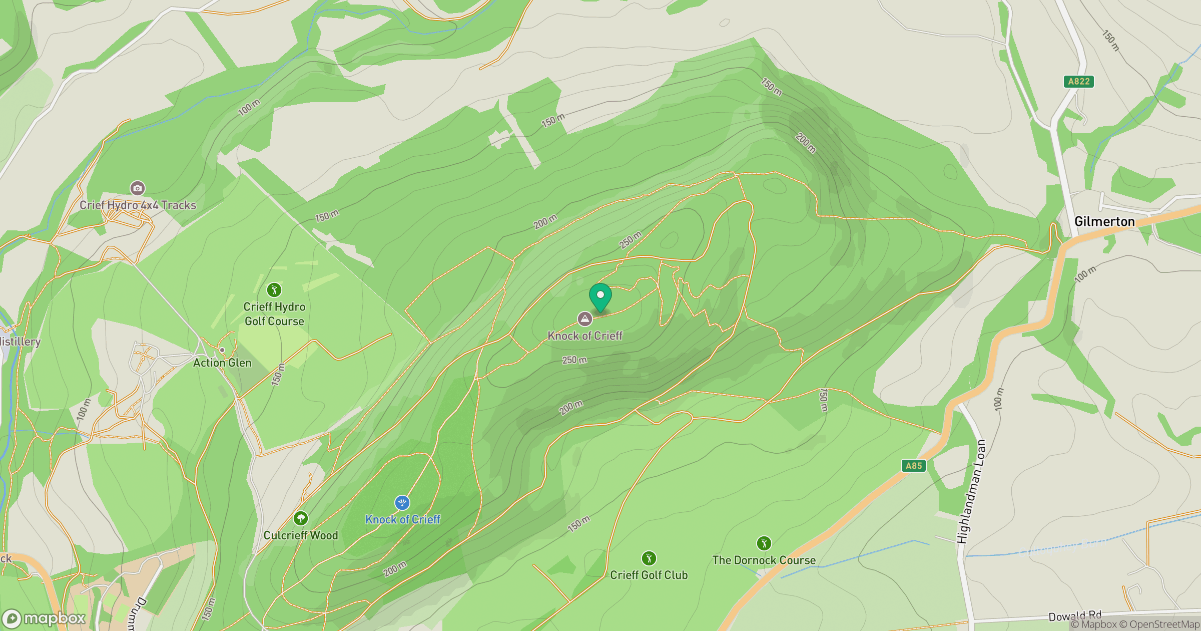
Grid reference: NN873234
View on OpenStreetMapOpens a map in a new tab, centred on the hill.
No comments yet. Be the first.