

Hambledon Hill
Good walks are even better shared.
ST8412 : Iron Age ramparts at Hambledon Hill
Sandy Gerrard Photo source
Overview
Hambledon Hill is a 192.2 m chalk hill above Child Okeford in Dorset, with prehistoric earthworks and views over the Blackmore Vale. The surveyed high point lies 40 m east-north-east of the trig point.
Hambledon Hill
Hambledon Hill rises to 192.2 m above Child Okeford in Dorset. Its unmarked surveyed summit is 40 m east-north-east of the trig point.
The hill combines chalk grassland with important prehistoric earthworks. Choose the village hillfort circuit or the longer Shroton circuit over Hambledon and Hod Hill, and plan the complete return to your starting point. Steep slopes, livestock and wet ground deserve care.
The village approach has very limited roadside parking. First Bus CR4 serves The Cross; check the current timetable before a bus-based walk.
Explore routes near Hambledon Hill
Walks starting near this hill. Open a route to check its map, distance and full itinerary.
Sturminster Newton, Cutt Mill and Stalbridge Lane
View route
Badbury Rings and The Oaks from Heron Drove, Dorset
View route
Hardy's Cottage, Stinsford and Dorchester from Thorncombe Wood
View route
Stourhead: Alfred's Tower, Park Hill Camp and Turner's Paddock
View route
Route planning notes
These notes describe possible approaches. Check a route's map and access information when planning your walk.
Child Okeford hillfort circuit
From Child Okeford follow the village Walk 3 approach via Shaftesbury Road and Pine Walk. Climb the northern ramparts and traverse the hillfort ridge. Circle the southern fortification, descend through its entrance to Markstone Cottages and return to the village by the field paths near Manor Drive. This is the complete hillfort circuit; the trig point and surveyed high point are separate from the main ridge circuit and require a detour.
Hambledon Hill and Hod Hill from Shroton
Walking Britain route 3695 is a complete Shroton circuit: start opposite St Mary’s Church, climb to Hambledon’s trig point, loop around the hillfort, then cross to Hod Hill and return via the White Hart Link and Fairfield Road. The published 9.8 km, 348 m ascent and about 3 h 50 min cover both hills and the return. Hambledon’s surveyed high point is 40 m east-north-east of its trig point.
Make a day of it, together
Find someone to share the walk with, or organise a day out along a route you like.
Photo Gallery
View all Photo could not load
ST8412 : Iron Age ramparts at Hambledon Hill
Sandy Gerrard
 Photo could not load
ST8412 : Pathway on Hambledon Hill
Chris Heaton
 Photo could not load
ST8412 : Hambledon Hill trig pillar
Clive Perrin
 Photo could not load
ST8412 : Iwerne Courtney: trig point and signpost on Hambledon Hill
Chris Downer
 Photo could not load
ST8412 : Trig Point on Hambledon Hill
Chris Heaton
 Photo could not load
ST8412 : Summit of Hambledon Hill
Jim Champion
Hill facts and local notes
Classifications
Elevation
192m
631 ft
Prominence
130m
Coordinates
50.9095, -2.2166
ST848122
OS Map
194
Explorer: 118N
At the Summit
The surveyed summit is unmarked ground 40 m east-north-east of the trig point. Ground 8 m west is equally high; the tumulus 450 m north-west is 0.4 m lower.
Terrain & Geology
Chalk underlies the hill and supports species-rich calcareous grassland.
Views & Scenery
Views extend over the Blackmore Vale and River Stour towards Dorset, Somerset and Wiltshire.
Best Seasons
Spring and summer bring chalk-grassland flowers; autumn colours enliven the lower paths.
History & Heritage
Name Origin
The Child Okeford local history account records Hameledun around 1270 and interprets the name as a scarred or mutilated hill, referring to its earthworks.
Historical Significance
Historic England records an Iron Age hillfort overlying Neolithic earthworks. Its exceptionally well-preserved interior includes evidence of prehistoric settlement planning; later medieval and post-medieval remains also survive.
Getting There & Facilities
Parking
No dedicated Hambledon Hill car park. National Trust identifies a small unsigned roadside lay-by south-east of Child Okeford with very limited space. Park considerately without blocking gates, drives or the highway. Village footpaths provide other approaches.
Public Transport
First Bus CR4 serves Child Okeford, The Cross, between Sturminster Newton and Blandford, with connections towards Yeovil. Check the current timetable and return service before travelling; the published weekday timetable excludes public holidays.
Nearby Facilities
Bring food and water for the hill. Child Okeford has a village shop and pubs; check opening times before relying on them.
Safety Information
Known Hazards
- Steep grass and chalk paths can be slippery when wet; watch for roots and badger setts on Pine Walk.
- Keep dogs under close control around livestock and follow on-site signs. Release the lead if threatened by cattle.
- Protect the ancient earthworks; horses must remain on bridleways.
- Road sections and limited roadside parking need care around traffic.
Seasonal Hazards
Wet weather makes the steep grassy slopes and muddy paths slippery; exposed ground can be windy.
General Safety Tips
- Check weather conditions before setting out
- Carry appropriate clothing and equipment
- Let someone know your planned route
- Take a map, compass, and GPS device
- Carry emergency supplies: food, water, first aid kit, torch
Hills
Some common questions about the hills answered
Are there group walks up Hambledon Hill?
Many walkers use Walkmates to join or organise walks with others. You can check for group walks around Hambledon Hill through the maps
Are there other walkers around Hambledon Hill?
Activity varies by location and time, but Walkmates lets you see whether others have shared walks or shown interest in this area. Find other people through the walking friends search walking friends for Hambledon Hill search or of course create your own walk for Hambledon Hill
Can I organise a walk to Hambledon Hill?
Yes. If there aren’t any walks listed already, you can create a walk and make it available for others to join.
If you're signed up to Walkmates, you can create a walk to Hambledon Hill.
How do I find a walk up this hill?
There are often multiple ways to walk this hill, depending on experience and route preference. Walkmates helps you explore walks and routes that others have shared.
Can I suggest a new route up Hambledon Hill?
Yes. You can suggest or create routes to share with others. Walkmates focuses on the social side of walking, so routes are used to help people organise walks and explore areas together, rather than as detailed navigation tools or route libraries.
Other uses really appreciate knowledgeable walkers sharing their routes. Share your favourite route to Hambledon Hill here
The is an error or something incorrect about this hill. How do I let you know?
We always strive to keep the information on Walkmates as accurate as possible. If you find an error, please let us know through the contact form and we'll aim to correct it as quickly as possible
Community Discussion
Comments
Location
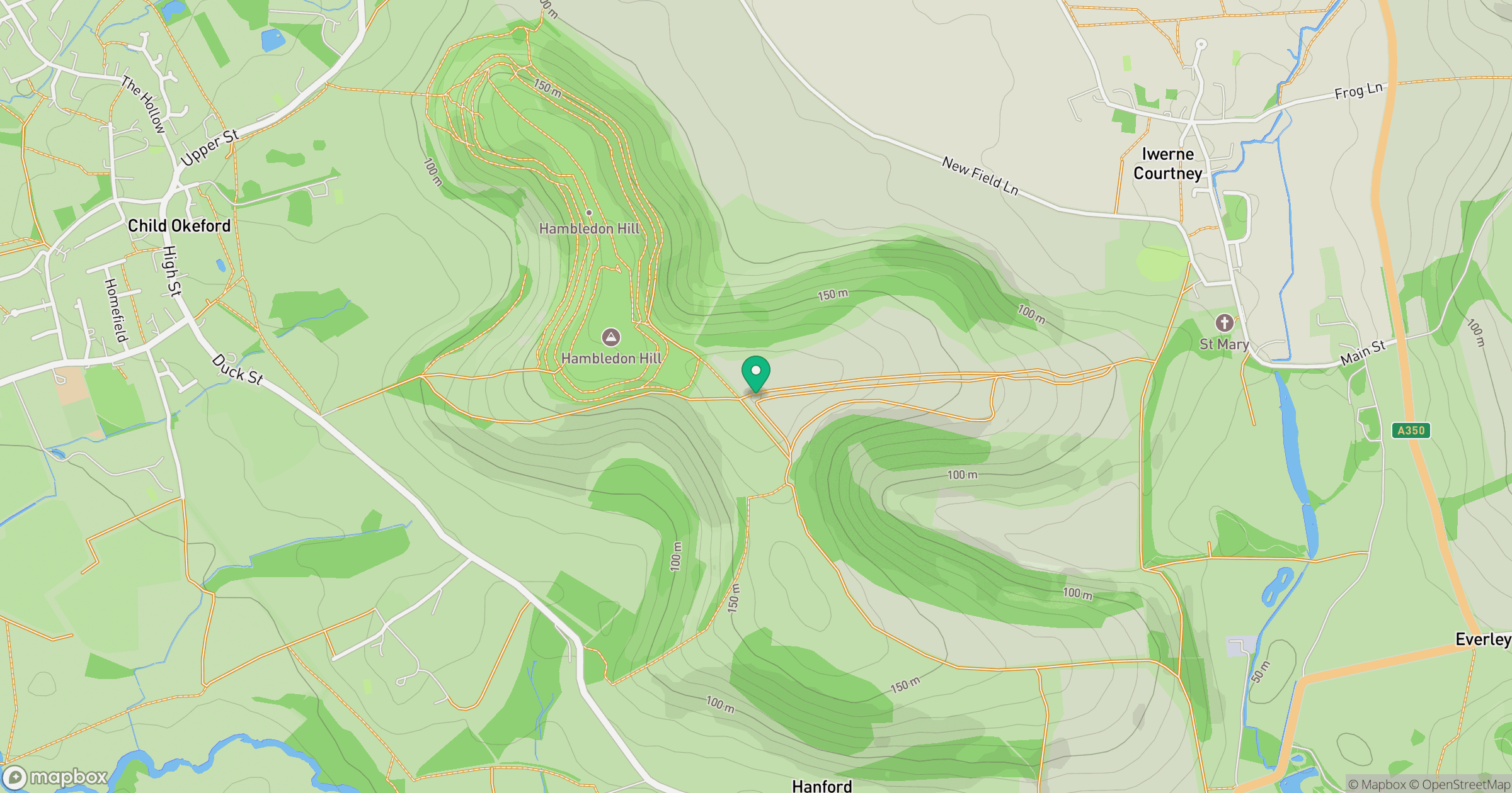
Grid reference: ST848122
View on OpenStreetMapOpens a map in a new tab, centred on the hill.
No comments yet. Be the first.