

Stob Coire Leith
Good walks are even better shared.
NN1458 : View from Sgorr nam Fiannaidh towards Stob Coire Leith and the Aonach Eagach
Steven Brown Photo source
Overview
Stob Coire Leith
Rising majestically to 1038 meters, Stob Coire Leith is a stunning Munro located in the heart of the Scottish Highlands. With its rugged terrain and breathtaking views, it is a favourite among hikers looking to experience the wild beauty of Scotland.
Geology
Stob Coire Leith is primarily composed of schist and granite, both of which were formed under immense pressure and heat dating back hundreds of millions of years. This rocky foundation creates the dramatic landscapes seen today, with craggy outcrops and deep glens that inspire awe.
Recommended Routes
- West Highland Way Approach: A moderate 8 km route that provides a gentle ascent while showcasing the beautiful surroundings of Glen Etive. A lovely warm-up for those not ready to dive straight into a challenge.
- North Ridge Route: For those who like a bit more excitement, this challenging 6.5 km route includes rocky scrambles and steep sections, rewarding your effort with breathtaking views from the summit.
Summit Features
At the summit, climbers are greeted by a modest stone cairn, which has seen many a satisfied hiker pose for a photo. The panoramic views are nothing short of spectacular, with the peaks of Ben Starav and the Black Mount vying for your attention.
Terrain
Expect rocky paths interspersed with grassy patches and the occasional bog. Good footwear is not just a suggestion—it's a necessity!
Views
The views from Stob Coire Leith are genuinely breathtaking. On a clear day, the mountains that surround Glen Etive offer a kaleidoscope of colours—a vibrant mix of greens, browns, and the occasional white cap of snow. The best time to bask in these views is typically spring or early autumn, when the air is clear and the light makes everything glow.
Hazards
While the ascent is rewarding, caution is advised. Loose rocks and unpredictable weather can pose challenges. Be prepared for anything; after all, the Highlands can be temperamental!
Nearby Summits
Don’t forget to check out Ben Starav and Beinn a' Chreachain, both of which provide additional hiking opportunities and stunning vistas.
Access
Parking is available at the end of the Glen Etive road, but be sure to arrive early, as spaces can fill quickly. Public transportation options are limited, thus a car is the best bet for reaching this majestic mountain.
Facilities
Plan to stop in Dalness for a coffee and a bite to eat after your hike—trust us, your legs will thank you!
History
The mountain’s Gaelic name hints at its rich cultural heritage, suggesting stories untold that linger in the landscape. Stob Coire Leith carries the spirit of the Highlands, having beckoned adventurers and nature enthusiasts for generations.
In conclusion, Stob Coire Leith is a gem that should be on every hiker's bucket list. Its stunning views, varied terrain, and inviting routes make it a rewarding experience for anyone ready to lace up their boots and embrace the wild.
Happy hiking!
Explore routes near Stob Coire Leith
Walks starting near this hill. Open a route to check its map, distance and full itinerary.
Ben Nevis via Mountain Path
View route
Banavie to Glen Loy Aqueduct: Neptune’s Staircase Canal Towpath
View route
West Highland Way: Tyndrum to Bridge of Orchy
View route
Coire Ardair lochan from Aberarder and back
View route
Route planning notes
These notes describe possible approaches. Check a route's map and access information when planning your walk.
West Highland Way Approach
A well-trodden path that winds up from the picturesque approach of Glen Etive, providing stunning views along the way.
North Ridge Route
This route offers a challenging ascent with rocky scrambles and delightful panoramas, perfect for seasoned hikers looking for a thrill.
Make a day of it, together
Find someone to share the walk with, or organise a day out along a route you like.
Photo Gallery
View all Photo could not load
NN1458 : View from Sgorr nam Fiannaidh towards Stob Coire Leith and the Aonach Eagach
Steven Brown
 Photo could not load
NN1558 : Just below Stob Coire Leith
Richard Law
 Photo could not load
NN1558 : Approaching Stob Coire Leith, Aonach Eagach
Jim Barton
 Photo could not load
NN1458 : Stob Coire Leith
Richard Webb
 Photo could not load
NN1458 : Peak of the Bens
Adam Ward
 Photo could not load
NN1458 : Ridge between Sgorr nam Fiannaidh and Stob Coire Leith
Steven Brown
 Photo could not load
NN1458 : The Aonach Eagach ridge with Ben Nevis in background as seen from Stob Coire nan Lochan
Colin Park
 Photo could not load
NN1458 : On Stob Coire Lèith
Russel Wills
 Photo could not load
NN1458 : Aonach Eagach
Adam Ward
Hill facts and local notes
Classifications
Elevation
940m
3,082 ft
Prominence
62m
Coordinates
56.6814, -5.0228
NN149584
OS Map
41
Explorer: 384
At the Summit
The summit is adorned by a modest cairn and provides an excellent viewpoint over the stunning Glen Etive.
Terrain & Geology
Stob Coire Leith is primarily composed of ancient schist and granite, giving it a rugged appearance that's perfect for the discerning walker keen on a touch of Highland magic.
Views & Scenery
From the summit, you can catch a glimpse of the neighbouring peaks of Ben Starav and the impressive ridge of the Black Mount.
History & Heritage
Name Origin
The name 'Stob Coire Leith' translates from Gaelic as 'Peak of the Grey Hollow', suggesting an ancient landscape steeped in heritage.
Historical Significance
Stob Coire Leith has been a classic Scottish walking destination for centuries, attracting climbers with its breathtaking scenery and challenging routes.
Getting There & Facilities
Parking
There’s a handy parking area at the end of the Glen Etive road (approximately NN 187 307) that holds several cars.
Public Transport
The nearest bus stops are in the village of Dalness, but services are infrequent. It's best to check local schedules.
Nearby Facilities
No facilities on-site, but there's a lovely cafe in Dalness where you can refuel after your hike.
Safety Information
Known Hazards
- Be wary of loose rocks, especially on the steeper sections. The weather can change abruptly, so having the right gear is crucial.
General Safety Tips
- Check weather conditions before setting out
- Carry appropriate clothing and equipment
- Let someone know your planned route
- Take a map, compass, and GPS device
- Carry emergency supplies: food, water, first aid kit, torch
Hills
Some common questions about the hills answered
Are there group walks up Stob Coire Leith?
Many walkers use Walkmates to join or organise walks with others. You can check for group walks around Stob Coire Leith through the maps
Are there other walkers around Stob Coire Leith?
Activity varies by location and time, but Walkmates lets you see whether others have shared walks or shown interest in this area. Find other people through the walking friends search walking friends for Stob Coire Leith search or of course create your own walk for Stob Coire Leith
Can I organise a walk to Stob Coire Leith?
Yes. If there aren’t any walks listed already, you can create a walk and make it available for others to join.
If you're signed up to Walkmates, you can create a walk to Stob Coire Leith.
How do I find a walk up this hill?
There are often multiple ways to walk this hill, depending on experience and route preference. Walkmates helps you explore walks and routes that others have shared.
Can I suggest a new route up Stob Coire Leith?
Yes. You can suggest or create routes to share with others. Walkmates focuses on the social side of walking, so routes are used to help people organise walks and explore areas together, rather than as detailed navigation tools or route libraries.
Other uses really appreciate knowledgeable walkers sharing their routes. Share your favourite route to Stob Coire Leith here
The is an error or something incorrect about this hill. How do I let you know?
We always strive to keep the information on Walkmates as accurate as possible. If you find an error, please let us know through the contact form and we'll aim to correct it as quickly as possible
Community Discussion
Comments
Location
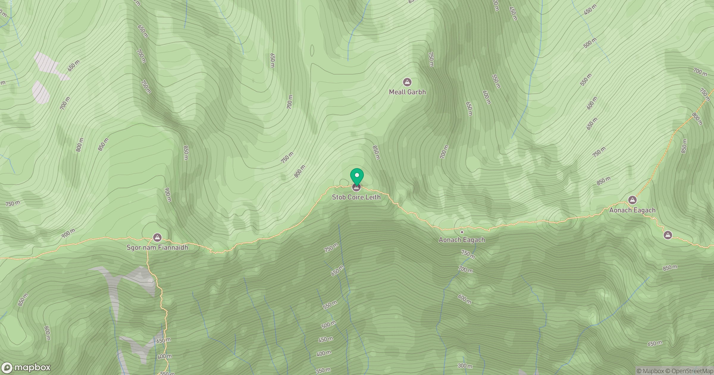
Grid reference: NN149584
View on OpenStreetMapOpens a map in a new tab, centred on the hill.
No comments yet. Be the first.