

Aonach Eagach - Sgorr nam Fiannaidh
Good walks are even better shared.
NN1458 : Sgurr nam Fiannaidh from the Aonach Eagach ridge
Tony Teperek Photo source
Overview
Aonach Eagach - Sgorr nam Fiannaidh
Introduction
Sgorr nam Fiannaidh, part of the famed Aonach Eagach range, is a gem for those seeking adventure in the Scottish Highlands. Rising boldly to 964 meters, this Munro is famed for its stunning vistas and thrilling ascents.
Geology
The mountain is primarily formed from Old Red Sandstone, which defines its rugged character. The intricate geological formations tell a story of the region's tumultuous past. As you wander the ridge, you might feel like a geologist on the brink of discovery – minus the lab coat of course!
Routes
Aonach Eagach Ridge
- Distance: 8.0 km
- Time: 6 hours
- Difficulty: Challenging
This route is not for the faint-hearted but offers rewarding views and exhilarating scrambles. If you’re up for some heights and dramatic scenery, you’re in for a real treat!
South East Approach
- Distance: 5.5 km
- Time: 4 hours
- Difficulty: Moderate
For those who prefer a less daunting path, this approach provides a quieter ascent with equally magnificent views without the heart-pounding scrambles.
Summit Features
At the summit, a substantial stone cairn greets you, offering a lovely spot for that well-deserved snack break. Don’t forget to take a selfie; it’s a view you’ll want to brag about on social media!
Terrain
Expect a mix of rocky outcrops, steep scrambles, and grassy patches. A solid pair of boots is essential, as even the most graceful among us can find faint footing in a dodgy spot.
Views
From the summit, you can enjoy breathtaking vistas of Loch Leven and far-off peaks like Buachaille Etive Mor. Spring and autumn provide the clearest views, especially in the early morning when the mist dances away like shy fairies.
Hazards
While the views are breathtaking, so are the potential hazards. Be mindful of steep drops, loose rocks, and swiftly changing weather conditions. It’s a good idea to turn back if the clouds start rolling in – safety first!
Nearby Summits
- Sgorr na Ciche: 1010 meters
- Meall Gorm: 763 meters
Access
Nearest Parking
Parking is available at the col near the B8043 road. Just keep an eye out for the signs; you wouldn't want to end up at a far-flung picnic spot instead!
Public Transport
Buses run regularly from Fort William to Glencoe, making access straightforward for those without a car. Don’t forget to look at the timetable ahead of your trip!
Facilities
Ballachulish is the closest town, offering basic amenities like cafes and shops. Perfect for refuelling after your hike.
History
Name Meaning
The name translates to 'Peak of the Fianna', linking the mountain to Scotland's rich mythological past.
Significance
The lore surrounding the Fianna adds a cultural richness that enhances the visitor experience, making it more than just a walk in the park.
Conclusion
Whether you're tackling the challenging ridge or taking a more gradual approach, Sgorr nam Fiannaidh offers a fantastic day out in one of Scotland's most beautiful landscapes. Just be sure to bring your camera – you'll want to capture every moment of this adventure!
Explore routes near Aonach Eagach - Sgorr nam Fiannaidh
Walks starting near this hill. Open a route to check its map, distance and full itinerary.
Ben Nevis via Mountain Path
View route
Banavie to Glen Loy Aqueduct: Neptune’s Staircase Canal Towpath
View route
Coire Ardair lochan from Aberarder and back
View route
Killin: Falls of Dochart, Finlarig and Moirlanich Longhouse
View route
Route planning notes
These notes describe possible approaches. Check a route's map and access information when planning your walk.
Aonach Eagach Traverse (Standard East-to-West)
This iconic ridge walk begins in Glencoe village at the parking area near NN173567. The route ascends steeply to Am Bodach, marking the east end of the Aonach Eagach ridge. From here, walkers traverse the exhilarating ridge, including airy scrambles and challenging pinnacles, passing Meall Dearg and reaching Sgorr nam Fiannaidh. The descent heads southwest to the Clachaig Gully path, which is steep and loose, ending near the Clachaig Inn.
Sgorr nam Fiannaidh via Clachaig Gully
A direct route to Sgorr nam Fiannaidh starting from the Clachaig Inn at NN128566. This route climbs steeply northward, following the Clachaig Gully path. While the gully itself is loose and requires care, the ascent offers excellent views of Glencoe. Upon reaching the summit of Sgorr nam Fiannaidh, walkers can enjoy panoramic vistas before descending via the same route.
Sgorr nam Fiannaidh Circular via Glen Etive
Starting from the small parking area at NN138548, this route ascends Sgorr nam Fiannaidh from Glen Etive. The climb is steep but rewarding, with views of Loch Etive and the surrounding peaks. From the summit, descend southwards towards the Beinn Fhada ridge, eventually looping back to Glen Etive for a less frequented approach.
Aonach Eagach Western Approach
For those wishing to avoid the full ridge traverse, this route starts at NN128566 near the Clachaig Inn and climbs directly to Sgorr nam Fiannaidh via Coire nam Beitheach. The ascent skirts the western end of the ridge, providing access to the summit without tackling the more challenging pinnacles. Descend the same way.
Aonach Eagach Ridge (West-to-East Traverse)
A less common option is to tackle the ridge in reverse, starting from the Clachaig Inn and ascending to Sgorr nam Fiannaidh. From here, traverse eastward, tackling the pinnacles and scrambles along the Aonach Eagach ridge, finishing at Am Bodach before descending to the road below. This route offers a unique perspective on the ridge but requires a car shuttle or a long walk back to the start.
Make a day of it, together
Find someone to share the walk with, or organise a day out along a route you like.
Photo Gallery
View all Photo could not load
NN1458 : Sgurr nam Fiannaidh from the Aonach Eagach ridge
Tony Teperek
 Photo could not load
NN1358 : Approaching Sgorr nam Fiannaidh from the west
Alan O'Dowd
 Photo could not load
NN1358 : View west from Sgorr nam Fiannaidh
Nigel Brown
 Photo could not load
NN1458 : View from Sgur nam Fiannaidh
wfmillar
 Photo could not load
NN1458 : Eastern summit of Sgorr nam Fiannaidh
Scott Cormie
 Photo could not load
NN1458 : Sgorr nam Fiannaidh summit
Scott Cormie
 Photo could not load
NN1458 : Sgorr nam Fiannaidh from east
Ian Taylor
 Photo could not load
NN1458 : Sgorr nam Fiannaidh
Nigel Brown
Hill facts and local notes
Classifications
Elevation
968m
3,175 ft
Prominence
623m
Coordinates
56.6794, -5.0371
NN140583
OS Map
41
Explorer: 384
At the Summit
The summit is marked by a large cairn, providing a perfect spot for a well-earned break and some stunning views.
Terrain & Geology
The mountain is composed mainly of Old Red Sandstone, which gives rise to its dramatic cliffs and rocky outcrops. The underlying geology provides insights into the geological history of the region.
Views & Scenery
Incredible views of Loch Leven, Glencoe, and the surrounding peaks, including Buachaille Etive Mor and the Mamores.
History & Heritage
Name Origin
The name 'Sgorr nam Fiannaidh' translates to 'Peak of the Fianna', referring to the legendary band of warriors in Scottish mythology.
Historical Significance
The mountain holds cultural significance in Scottish lore, often associated with the tales of the Fianna and their exploits.
Getting There & Facilities
Parking
There is parking available at the col between the Aonach Eagach and the B8043 road near the car park for the Pap of Glencoe.
Public Transport
Buses from Fort William to Glencoe run regularly, with a short walk to the start of the trails.
Nearby Facilities
There are basic facilities in Ballachulish, including cafes, a shop, and public toilets.
Safety Information
Known Hazards
- Steep drops along the ridge, loose stones, and rapidly changing weather conditions can pose risks.
General Safety Tips
- Check weather conditions before setting out
- Carry appropriate clothing and equipment
- Let someone know your planned route
- Take a map, compass, and GPS device
- Carry emergency supplies: food, water, first aid kit, torch
Hills
Some common questions about the hills answered
Are there group walks up Aonach Eagach - Sgorr nam Fiannaidh?
Many walkers use Walkmates to join or organise walks with others. You can check for group walks around Aonach Eagach - Sgorr nam Fiannaidh through the maps
Are there other walkers around Aonach Eagach - Sgorr nam Fiannaidh?
Activity varies by location and time, but Walkmates lets you see whether others have shared walks or shown interest in this area. Find other people through the walking friends search walking friends for Aonach Eagach - Sgorr nam Fiannaidh search or of course create your own walk for Aonach Eagach - Sgorr nam Fiannaidh
Can I organise a walk to Aonach Eagach - Sgorr nam Fiannaidh?
Yes. If there aren’t any walks listed already, you can create a walk and make it available for others to join.
If you're signed up to Walkmates, you can create a walk to Aonach Eagach - Sgorr nam Fiannaidh.
How do I find a walk up this hill?
There are often multiple ways to walk this hill, depending on experience and route preference. Walkmates helps you explore walks and routes that others have shared.
Can I suggest a new route up Aonach Eagach - Sgorr nam Fiannaidh?
Yes. You can suggest or create routes to share with others. Walkmates focuses on the social side of walking, so routes are used to help people organise walks and explore areas together, rather than as detailed navigation tools or route libraries.
Other uses really appreciate knowledgeable walkers sharing their routes. Share your favourite route to Aonach Eagach - Sgorr nam Fiannaidh here
The is an error or something incorrect about this hill. How do I let you know?
We always strive to keep the information on Walkmates as accurate as possible. If you find an error, please let us know through the contact form and we'll aim to correct it as quickly as possible
Community Discussion
Comments
Location
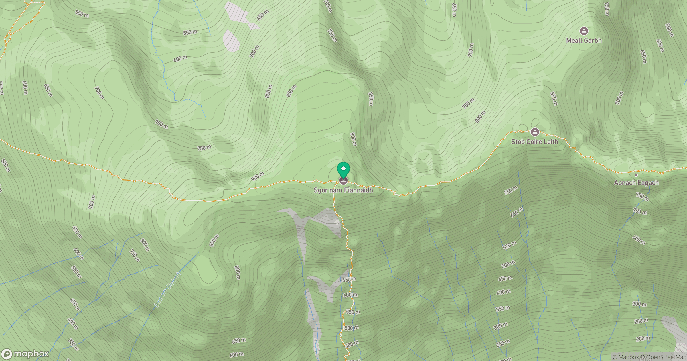
Grid reference: NN140583
View on OpenStreetMapOpens a map in a new tab, centred on the hill.
No comments yet. Be the first.