

Aonach Eagach - Meall Dearg
Good walks are even better shared.
NN1658 : West to the Aonach Eagach
Jim Barton Photo source
Overview
Aonach Eagach - Meall Dearg
Overview
Aonach Eagach is a stunning Munro located in the heart of the Scottish Highlands, standing tall at 958 meters. Not just your average hill, it features dramatic landscapes and a thrilling sense of adventure that beckons hikers from all over.
Geology
The geology of Aonach Eagach is fascinating, comprising mostly Old Red Sandstone. These ancient rocks give rise to some stunning cliffs, steep slopes, and the rich colours that embellish the hillsides. A good excuse to unleash your inner geology nerd!
Routes
The most popular route is the Aonach Eagach Ridge Walk, a challenging 11.5 km journey that offers both excitement and stunning views. Budget around 6.5 hours for this strenuous trek; you wouldn't want to leave any boulder unturned on this glorious ridge!
Summit Features
On reaching the summit, you’ll find a substantial cairn marking the top, acting as a perfect backdrop for a celebratory photograph, or as a brief resting point for those gasping for breath (or something else).
Terrain Type
Prepare yourself for rocky, steep terrain. This walk is not for the faint-hearted, featuring sections that require at least a little scrambly skill. But fear not; you'll feel like a mountain goat by the time you reach the top!
Views
From the summit, the panoramic views are simply divine. You can spot the majestic Glen Coe valley, the distinct shape of Pap of Glencoe, and on clear days, catch a glimpse of Loch Leven in the distance.
Best Seasons
The ideal times for maximising those jaw-dropping views are spring and early autumn. During these seasons, the weather tends to cooperate, and your chances of a clear sighting become far more optimistic.
Hazards
Be aware of loose rocks and steep drops; this isn't a Sunday stroll in the park! As the weather in the Highlands can change in the blink of an eye, being prepared is the name of the game.
Nearby Summits
Check out neighbouring peaks like Meall A'Bhuird (967 m) and Bidean Nam Bian (1150 m) for even more Highland escapades!
Access
The nearest parking is at the car park near the end of the A82 at the head of Glencoe (NN 141 558). Be warned: it gets busy, so arrive bright and early! Public transport options include buses from Fort William and Ballachulish, while Ballachulish itself is the closest town, just 10 km away.
Facilities
If you're looking to refuel after this epic journey, Ballachulish has you covered with various cafes and restaurants. And yes, toilets are available, so you can do your business before heading out again.
History
The name Meall Dearg translates to 'Red Hill', aptly describing the striking hues of the hillside. Historically, Aonach Eagach has been significant for climbers and adventurers alike, making it a beloved spot in the Scottish outdoors.
So lace up your boots, grab your walking poles, and immerse yourself in the beauty of Aonach Eagach - Meall Dearg!
Explore routes near Aonach Eagach - Meall Dearg
Walks starting near this hill. Open a route to check its map, distance and full itinerary.
Ben Nevis via Mountain Path
View route
Banavie to Glen Loy Aqueduct: Neptune’s Staircase Canal Towpath
View route
Killin: Falls of Dochart, Finlarig and Moirlanich Longhouse
View route
Beinn Ime from Succoth
View route
Route planning notes
These notes describe possible approaches. Check a route's map and access information when planning your walk.
Aonach Eagach Ridge Traverse (East to West)
This is the classic traverse of the Aonach Eagach Ridge, starting at the layby near Allt-na-reigh on the A82. It begins with a steep ascent to Am Bodach, followed by a thrilling scramble along the ridge to Meall Dearg and continuing westward to Stob Coire Leith and Sgorr nam Fiannaidh. The descent is via the Clachaig Gully path. This route is highly exposed and requires scrambling experience.
Meall Dearg Out-and-Back from Allt-na-reigh
This route focuses on reaching Meall Dearg without traversing the entire Aonach Eagach Ridge. Starting at the Allt-na-reigh layby on the A82, the route ascends steeply to Am Bodach before heading east to Meall Dearg. Return via the same path, avoiding the more challenging scrambling sections of the ridge.
Aonach Eagach Ridge Traverse (West to East)
This variation of the classic traverse begins at Glencoe Village, ascending Sgorr nam Fiannaidh first before tackling the full Aonach Eagach Ridge eastwards to Am Bodach. The descent is made via the Allt-na-reigh path. This direction is less common but equally exhilarating, requiring advanced scrambling skills.
Meall Dearg Approach via Coire nan Lochan
For a quieter and less direct route to Meall Dearg, start from the Hidden Valley car park and ascend into Coire nan Lochan. From here, head northeast to intersect the ridge near Meall Dearg. Return via the same route or continue onto the Aonach Eagach Ridge if experienced.
Meall Dearg via Kinlochleven Circuit
This extended route begins in Kinlochleven, following the West Highland Way to ascend to the ridge near Meall Dearg. This approach offers a longer and more gradual ascent, ideal for those looking to explore the surrounding Glencoe area. Return via the same path.
Make a day of it, together
Find someone to share the walk with, or organise a day out along a route you like.
Photo Gallery
View all Photo could not load
NN1658 : West to the Aonach Eagach
Jim Barton
 Photo could not load
NN1658 : Westwards from The Chancellor
Richard Law
Hill facts and local notes
Classifications
Elevation
952m
3,124 ft
Prominence
120m
Coordinates
56.6807, -5.0032
NN161583
OS Map
41
Explorer: 384
At the Summit
The summit features a prominent cairn and offers panoramic views of the surrounding mountains and valleys.
Terrain & Geology
The Aonach Eagach ridge is primarily composed of Old Red Sandstone, which gives it some dramatic cliff faces and rugged features. The area is also known for its striking volcanic rock formations.
Views & Scenery
Highlights include views of the impressive Glen Coe valley, the Pap of Glencoe, and in clear conditions, the distant expanse of Loch Leven.
History & Heritage
Name Origin
Meall Dearg translates to 'Red Hill', likely referring to the reddish hue of the rock in certain lights and weather conditions.
Historical Significance
The Aonach Eagach ridge has been a significant location for mountaineers and climbers, renowned for its dramatic beauty and challenging routes.
Getting There & Facilities
Parking
There is a car park near the end of the A82 at the head of Glencoe (NN 141 558). It can get busy during peak seasons, so arrive early.
Public Transport
Buses to Glencoe are available from nearby towns, including Fort William and Ballachulish.
Nearby Facilities
Facilities in Ballachulish include cafes, restaurants, and basic shops. Toilets can be found in the village.
Safety Information
Known Hazards
- Loose rocks and steep drops can present risks. Weather changes rapidly in the Highlands, so always be prepared.
General Safety Tips
- Check weather conditions before setting out
- Carry appropriate clothing and equipment
- Let someone know your planned route
- Take a map, compass, and GPS device
- Carry emergency supplies: food, water, first aid kit, torch
Hills
Some common questions about the hills answered
Are there group walks up Aonach Eagach - Meall Dearg?
Many walkers use Walkmates to join or organise walks with others. You can check for group walks around Aonach Eagach - Meall Dearg through the maps
Are there other walkers around Aonach Eagach - Meall Dearg?
Activity varies by location and time, but Walkmates lets you see whether others have shared walks or shown interest in this area. Find other people through the walking friends search walking friends for Aonach Eagach - Meall Dearg search or of course create your own walk for Aonach Eagach - Meall Dearg
Can I organise a walk to Aonach Eagach - Meall Dearg?
Yes. If there aren’t any walks listed already, you can create a walk and make it available for others to join.
If you're signed up to Walkmates, you can create a walk to Aonach Eagach - Meall Dearg.
How do I find a walk up this hill?
There are often multiple ways to walk this hill, depending on experience and route preference. Walkmates helps you explore walks and routes that others have shared.
Can I suggest a new route up Aonach Eagach - Meall Dearg?
Yes. You can suggest or create routes to share with others. Walkmates focuses on the social side of walking, so routes are used to help people organise walks and explore areas together, rather than as detailed navigation tools or route libraries.
Other uses really appreciate knowledgeable walkers sharing their routes. Share your favourite route to Aonach Eagach - Meall Dearg here
The is an error or something incorrect about this hill. How do I let you know?
We always strive to keep the information on Walkmates as accurate as possible. If you find an error, please let us know through the contact form and we'll aim to correct it as quickly as possible
Community Discussion
Comments
Location
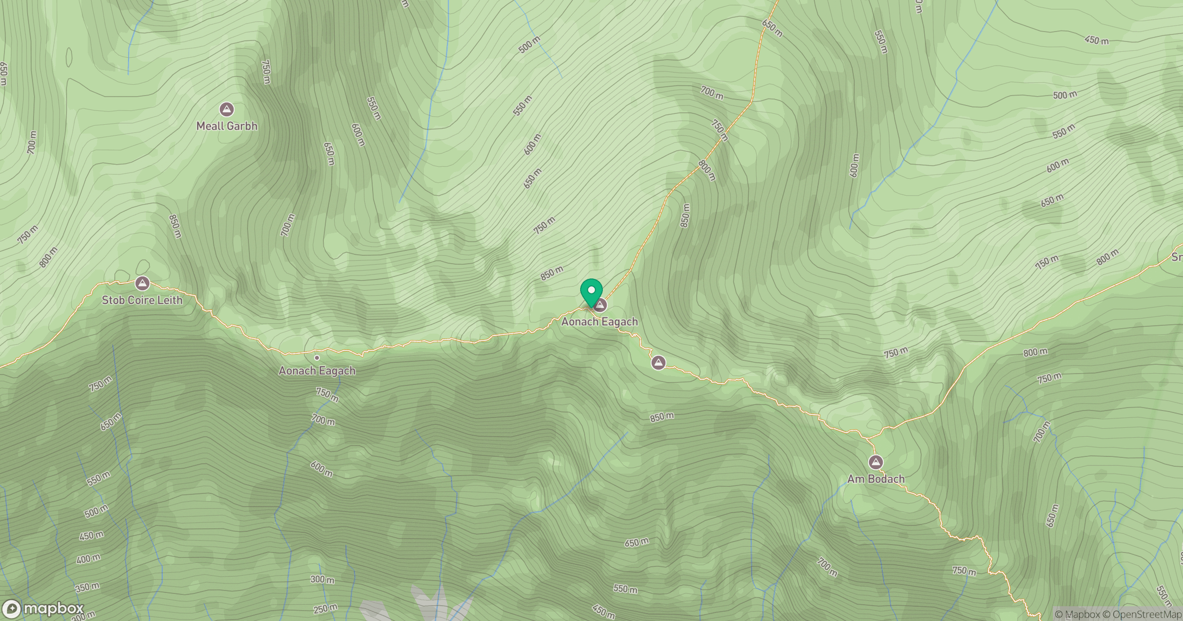
Grid reference: NN161583
View on OpenStreetMapOpens a map in a new tab, centred on the hill.
No comments yet. Be the first.