

Bidean nam Bian
Good walks are even better shared.
NN1454 : The ridge linking Stob Coire nan Lochan to Bidean nam Bian
Colin Park Photo source
Overview
Bidean nam Bian is Glen Coe’s highest mountain, a 1,149.4 m Munro whose main summit is hidden behind the famous Three Sisters and their higher neighbours. It is a complex massif of rocky ridges, steep corries and crags. A Bidean-only return crosses Stob Coire nan Lochan; longer circuits add Stob Coire Sgreamhach. These are demanding mountain days requiring fitness, navigation and care on steep ground.
Bidean nam Bian
Overview
Bidean nam Bian is Glen Coe’s highest mountain, a 1,149.4 m Munro whose main summit is hidden behind the famous Three Sisters and their higher neighbours. It is a complex massif of rocky ridges, steep corries and crags. A Bidean-only return crosses Stob Coire nan Lochan; longer circuits add Stob Coire Sgreamhach. These are demanding mountain days requiring fitness, navigation and care on steep ground.
Summit and views
The main summit is marked by a cairn at NN 14345 54201 and is 1,149.4 m high. The top about 200 m west-northwest is lower, at 1,141.1 m. Stob Coire nan Lochan (1,115.6 m) is a separate Munro Top on the northern approach, not Bidean’s main summit. In clear weather the summit panorama includes Loch Etive, Mull, Beinn a’ Bheithir, the Aonach Eagach and Ben Nevis. Stob Coire Sgreamhach adds views towards Buachaille Etive Beag and Buachaille Etive Mor.
Routes
Bidean nam Bian via Stob Coire nan Lochan, out and back
Start at the main Three Sisters car park (Walking Britain: NN170568). Cross the River Coe footbridge and climb Coire nan Lochan. Take the scrambly ledge near NN155552 into the upper corrie, then the eastern ridge to Stob Coire nan Lochan. Cross the intervening col and follow the connecting ridge to Bidean’s main summit. Return over Stob Coire nan Lochan and reverse this same eastern-ridge, corrie and footbridge approach to the car park. Walking Britain gives 8.1 km, 1,227 m ascent and 6 hours 20 minutes. Steep rock and nearby cliffs demand careful navigation on the descent.
Bidean nam Bian and Stob Coire Sgreamhach, Lost Valley circuit
From the main Three Sisters car park (NN170569), cross the River Coe and ascend Coire nan Lochan. Take the upper-corrie path to Stob Coire nan Lochan’s north ridge, then cross its summit and the col to Bidean. Follow the southeast ridge to Bealach Dearg and climb Stob Coire Sgreamhach. Retrace to Bealach Dearg, then descend north into Coire Gabhail and the Lost Valley. Follow the rocky gorge path, cross the burn on stepping stones and the river by its bridge, then return along the glen track to the original car park. Walkhighlands gives 11 km, 1,316 m ascent and 7–9 hours. The steep, loose headwall can retain snow well into summer; do not commit to it without suitable conditions and skills.
Bidean and Stob Coire Sgreamhach via Lairig Eilde, circuit
Start and finish at Lairig Eilde car park (NN187562). Follow the pass path, crossing and re-crossing the burn. From its high point, go west-southwest over rough ground and climb the grassy corrie to the col southeast of Stob Coire Sgreamhach; ascend its ridge. Continue over Bealach Dearg to Bidean, then north over the connecting col to Stob Coire nan Lochan. Descend its eastern ridge into Coire nan Lochan and follow the path to the River Coe footbridge. Turn east onto the old-road track before the A82; use further old-road stretches beyond Allt na Reigh and the intervening road sections to regain the original car park. UKHillwalking gives 13.86 km, 1,385 m ascent and 6 walking hours; allow additional time for breaks and conditions. The upper ascent is indistinct and the A82 sections need care.
Terrain and safety
Steep, rocky and sometimes indistinct mountain paths; boulder-covered ridges, scree, rock steps and occasional scrambling. Coire nan Lochan has steep pitched paths and rough upper ground. The Lost Valley circuit adds a loose headwall, rocky gorge and burn crossing. The Lairig Eilde alternative includes boggy, poorly defined upper slopes and short road sections on its return.
- Steep rocky ridges, loose scree and crags make route-finding serious in cloud. Carry a map and compass and know how to use them; do not improvise descents over summit or corrie cliffs.
- The descent north from Bealach Dearg into Coire Gabhail is very steep, eroded and loose. Check it before committing to the Lost Valley circuit; a snow-covered headwall requires appropriate winter skills and equipment.
- The Lost Valley exit includes rock steps and exposed drops. Its stepping-stone burn crossing, and the Lairig Eilde crossings, can become difficult after heavy rain; turn back rather than enter unsafe water.
- The Lairig Eilde circuit returns using old-road paths with short A82 sections. Watch for traffic and use designated parking without obstructing the road, coach spaces or emergency access.
- Beinn Fhada’s crest and the Sron na Lairig scrambling line are separate from the Lairig Eilde pass approach described here. The Beinn Fhada ridge has an exposed Bad Step and complex route-finding; it is not a casual alternative descent.
- Strong winds, cold and rain can affect the high ground in any season. Check a mountain forecast, carry warm waterproof clothing, food, water and a headtorch, and leave your route and expected return with someone.
Snow can remain at the head of Coire Gabhail well into summer. In snow and ice, these routes become mountaineering undertakings: summer paths may be hidden or unsafe, with cornices, hard snow, icy rock and avalanche terrain. Ice axe, crampons, winter navigation and the skills to assess and use them are essential. Graded gullies and climbing lines are separate routes, not shortcuts through Coire nan Lochan. Check current mountain weather and SAIS Glencoe information when forecasts are operating; lack of a forecast does not mean no avalanche hazard. Allow for short daylight and slower travel. Follow current NTS access notices and signs, and keep dogs under close control.
Access and facilities
Glencoe village and Ballachulish are the nearby settlements west of the mountain, with services along the A82.
For the Coire nan Lochan and Lost Valley routes, use the main Three Sisters car park on the A82 at NN170569 (Walking Britain gives NN170568 for the same starting area). NTS’s redesign places car bays in the larger area and reserves the smaller area for buses and coaches; follow current signs and parking terms. The Lairig Eilde circuit has a different start at NN187562. Park only in designated spaces and keep the A82 verge, gates and emergency access clear.
NTS confirms daily Glasgow–Fort William buses stop at the visitor-centre junction on the A82; local buses terminate in Glencoe village. These are separate from the mountain starts. Check the operator’s current timetable, booked stop, onward transport to the Three Sisters or Lairig Eilde, and last return before setting out.
The mountain routes have no toilets or refreshment facilities. Glencoe visitor centre has toilets and a café; check opening times. NTS directs visitors to public toilets in Glencoe village when the centre’s toilets are closed. Carry food and drinking water for the full mountain day.
Geology
Bidean is a type area for the Early Devonian Glencoe Volcanic Formation. The sequence includes andesite, rhyolite, volcanic tuffs and breccias above older Dalradian rocks. The JNCC account describes lower Leven Schist, a basal sill complex, rhyolites and ignimbrites, collapse deposits and higher andesites within Glencoe’s down-faulted volcanic block. It is not simply a mountain of schist and granite.
Names and history
Often rendered as “peak of the mountains”, but the name’s origin is disputed. Place-name scholar Peter Drummond discusses Bidean nam Bian as “peak of hides” and the alternative form Bidean nam Beann. “Peak of the cows” is not supported by this research. The Lost Valley has a strong association with the MacDonalds of Glencoe. The National Trust for Scotland recounts its use to conceal cattle and as a refuge during the 1692 Glencoe Massacre. This is the history of the valley below the massif, rather than a claim about events on Bidean’s summit.
Nearby landscape
The Three Sisters are the northward ridges of Aonach Dubh, Gearr Aonach and Beinn Fhada. Coire nan Lochan lies between Aonach Dubh and Gearr Aonach; Coire Gabhail, the Lost Valley, lies between Gearr Aonach and Beinn Fhada. Bidean’s main summit stands farther back. Church Door Buttress lies beneath its northern side.
Explore routes near Bidean nam Bian
Walks starting near this hill. Open a route to check its map, distance and full itinerary.
Ben Nevis via Mountain Path
View route
Banavie to Glen Loy Aqueduct: Neptune’s Staircase Canal Towpath
View route
West Highland Way: Tyndrum to Bridge of Orchy
View route
Coire Ardair lochan from Aberarder and back
View route
Route planning notes
These notes describe possible approaches. Check a route's map and access information when planning your walk.
Bidean nam Bian via Stob Coire nan Lochan, out and back
Start at the main Three Sisters car park (Walking Britain: NN170568). Cross the River Coe footbridge and climb Coire nan Lochan. Take the scrambly ledge near NN155552 into the upper corrie, then the eastern ridge to Stob Coire nan Lochan. Cross the intervening col and follow the connecting ridge to Bidean’s main summit. Return over Stob Coire nan Lochan and reverse this same eastern-ridge, corrie and footbridge approach to the car park. Walking Britain gives 8.1 km, 1,227 m ascent and 6 hours 20 minutes. Steep rock and nearby cliffs demand careful navigation on the descent.
Bidean nam Bian and Stob Coire Sgreamhach, Lost Valley circuit
From the main Three Sisters car park (NN170569), cross the River Coe and ascend Coire nan Lochan. Take the upper-corrie path to Stob Coire nan Lochan’s north ridge, then cross its summit and the col to Bidean. Follow the southeast ridge to Bealach Dearg and climb Stob Coire Sgreamhach. Retrace to Bealach Dearg, then descend north into Coire Gabhail and the Lost Valley. Follow the rocky gorge path, cross the burn on stepping stones and the river by its bridge, then return along the glen track to the original car park. Walkhighlands gives 11 km, 1,316 m ascent and 7–9 hours. The steep, loose headwall can retain snow well into summer; do not commit to it without suitable conditions and skills.
Bidean and Stob Coire Sgreamhach via Lairig Eilde, circuit
Start and finish at Lairig Eilde car park (NN187562). Follow the pass path, crossing and re-crossing the burn. From its high point, go west-southwest over rough ground and climb the grassy corrie to the col southeast of Stob Coire Sgreamhach; ascend its ridge. Continue over Bealach Dearg to Bidean, then north over the connecting col to Stob Coire nan Lochan. Descend its eastern ridge into Coire nan Lochan and follow the path to the River Coe footbridge. Turn east onto the old-road track before the A82; use further old-road stretches beyond Allt na Reigh and the intervening road sections to regain the original car park. UKHillwalking gives 13.86 km, 1,385 m ascent and 6 walking hours; allow additional time for breaks and conditions. The upper ascent is indistinct and the A82 sections need care.
Make a day of it, together
Find someone to share the walk with, or organise a day out along a route you like.
Photo Gallery
View all Photo could not load
NN1454 : The ridge linking Stob Coire nan Lochan to Bidean nam Bian
Colin Park
 Photo could not load
NN1454 : Bidean nan Bian
Richard Webb
 Photo could not load
NN1454 : View from Bidean Nam Bian
Roger
 Photo could not load
NN1454 : Perfect autumn day on Bidean nam Bian
Alan Reid
 Photo could not load
NN1454 : Bidean nam Bian Summit
wfmillar
 Photo could not load
NN1454 : On Buachaille Etive Beag - View to Bidean nam Bian from Stob Coire Raineach
Colin Park
 Photo could not load
NN1454 : Bidean nam Bian
Simon McElroy
 Photo could not load
NN1454 : Bidean nam Bian from Stob Coire nan Lochan
Trevor Littlewood
 Photo could not load
NN1454 : The hills of Bidean nam Bian from Stob Coire Leith on the Aonach Eagach ridge
Richard Law

NN1454 : Twin summits of Bidean nam Bian
Alan Reid
Hill facts and local notes
Classifications
Elevation
1,149m
3,771 ft
Prominence
844m
Coordinates
56.6428, -5.0293
NN143542
OS Map
41
Explorer: 384
At the Summit
The main summit is marked by a cairn at NN 14345 54201 and is 1,149.4 m high. The top about 200 m west-northwest is lower, at 1,141.1 m. Stob Coire nan Lochan (1,115.6 m) is a separate Munro Top on the northern approach, not Bidean’s main summit.
Terrain & Geology
Bidean is a type area for the Early Devonian Glencoe Volcanic Formation. The sequence includes andesite, rhyolite, volcanic tuffs and breccias above older Dalradian rocks. The JNCC account describes lower Leven Schist, a basal sill complex, rhyolites and ignimbrites, collapse deposits and higher andesites within Glencoe’s down-faulted volcanic block. It is not simply a mountain of schist and granite.
Views & Scenery
In clear weather the summit panorama includes Loch Etive, Mull, Beinn a’ Bheithir, the Aonach Eagach and Ben Nevis. Stob Coire Sgreamhach adds views towards Buachaille Etive Beag and Buachaille Etive Mor.
History & Heritage
Name Origin
Often rendered as “peak of the mountains”, but the name’s origin is disputed. Place-name scholar Peter Drummond discusses Bidean nam Bian as “peak of hides” and the alternative form Bidean nam Beann. “Peak of the cows” is not supported by this research.
Historical Significance
The Lost Valley has a strong association with the MacDonalds of Glencoe. The National Trust for Scotland recounts its use to conceal cattle and as a refuge during the 1692 Glencoe Massacre. This is the history of the valley below the massif, rather than a claim about events on Bidean’s summit.
Getting There & Facilities
Parking
For the Coire nan Lochan and Lost Valley routes, use the main Three Sisters car park on the A82 at NN170569 (Walking Britain gives NN170568 for the same starting area). NTS’s redesign places car bays in the larger area and reserves the smaller area for buses and coaches; follow current signs and parking terms. The Lairig Eilde circuit has a different start at NN187562. Park only in designated spaces and keep the A82 verge, gates and emergency access clear.
Public Transport
NTS confirms daily Glasgow–Fort William buses stop at the visitor-centre junction on the A82; local buses terminate in Glencoe village. These are separate from the mountain starts. Check the operator’s current timetable, booked stop, onward transport to the Three Sisters or Lairig Eilde, and last return before setting out.
Nearby Facilities
The mountain routes have no toilets or refreshment facilities. Glencoe visitor centre has toilets and a café; check opening times. NTS directs visitors to public toilets in Glencoe village when the centre’s toilets are closed. Carry food and drinking water for the full mountain day.
Safety Information
Known Hazards
- Steep rocky ridges, loose scree and crags make route-finding serious in cloud. Carry a map and compass and know how to use them; do not improvise descents over summit or corrie cliffs.
- The descent north from Bealach Dearg into Coire Gabhail is very steep, eroded and loose. Check it before committing to the Lost Valley circuit; a snow-covered headwall requires appropriate winter skills and equipment.
- The Lost Valley exit includes rock steps and exposed drops. Its stepping-stone burn crossing, and the Lairig Eilde crossings, can become difficult after heavy rain; turn back rather than enter unsafe water.
- The Lairig Eilde circuit returns using old-road paths with short A82 sections. Watch for traffic and use designated parking without obstructing the road, coach spaces or emergency access.
- Beinn Fhada’s crest and the Sron na Lairig scrambling line are separate from the Lairig Eilde pass approach described here. The Beinn Fhada ridge has an exposed Bad Step and complex route-finding; it is not a casual alternative descent.
- Strong winds, cold and rain can affect the high ground in any season. Check a mountain forecast, carry warm waterproof clothing, food, water and a headtorch, and leave your route and expected return with someone.
Seasonal Hazards
Snow can remain at the head of Coire Gabhail well into summer. In snow and ice, these routes become mountaineering undertakings: summer paths may be hidden or unsafe, with cornices, hard snow, icy rock and avalanche terrain. Ice axe, crampons, winter navigation and the skills to assess and use them are essential. Graded gullies and climbing lines are separate routes, not shortcuts through Coire nan Lochan. Check current mountain weather and SAIS Glencoe information when forecasts are operating; lack of a forecast does not mean no avalanche hazard. Allow for short daylight and slower travel. Follow current NTS access notices and signs, and keep dogs under close control.
General Safety Tips
- Check weather conditions before setting out
- Carry appropriate clothing and equipment
- Let someone know your planned route
- Take a map, compass, and GPS device
- Carry emergency supplies: food, water, first aid kit, torch
Hills
Some common questions about the hills answered
Are there group walks up Bidean nam Bian?
Many walkers use Walkmates to join or organise walks with others. You can check for group walks around Bidean nam Bian through the maps
Are there other walkers around Bidean nam Bian?
Activity varies by location and time, but Walkmates lets you see whether others have shared walks or shown interest in this area. Find other people through the walking friends search walking friends for Bidean nam Bian search or of course create your own walk for Bidean nam Bian
Can I organise a walk to Bidean nam Bian?
Yes. If there aren’t any walks listed already, you can create a walk and make it available for others to join.
If you're signed up to Walkmates, you can create a walk to Bidean nam Bian.
How do I find a walk up this hill?
There are often multiple ways to walk this hill, depending on experience and route preference. Walkmates helps you explore walks and routes that others have shared.
Can I suggest a new route up Bidean nam Bian?
Yes. You can suggest or create routes to share with others. Walkmates focuses on the social side of walking, so routes are used to help people organise walks and explore areas together, rather than as detailed navigation tools or route libraries.
Other uses really appreciate knowledgeable walkers sharing their routes. Share your favourite route to Bidean nam Bian here
The is an error or something incorrect about this hill. How do I let you know?
We always strive to keep the information on Walkmates as accurate as possible. If you find an error, please let us know through the contact form and we'll aim to correct it as quickly as possible
Community Discussion
Comments
Location
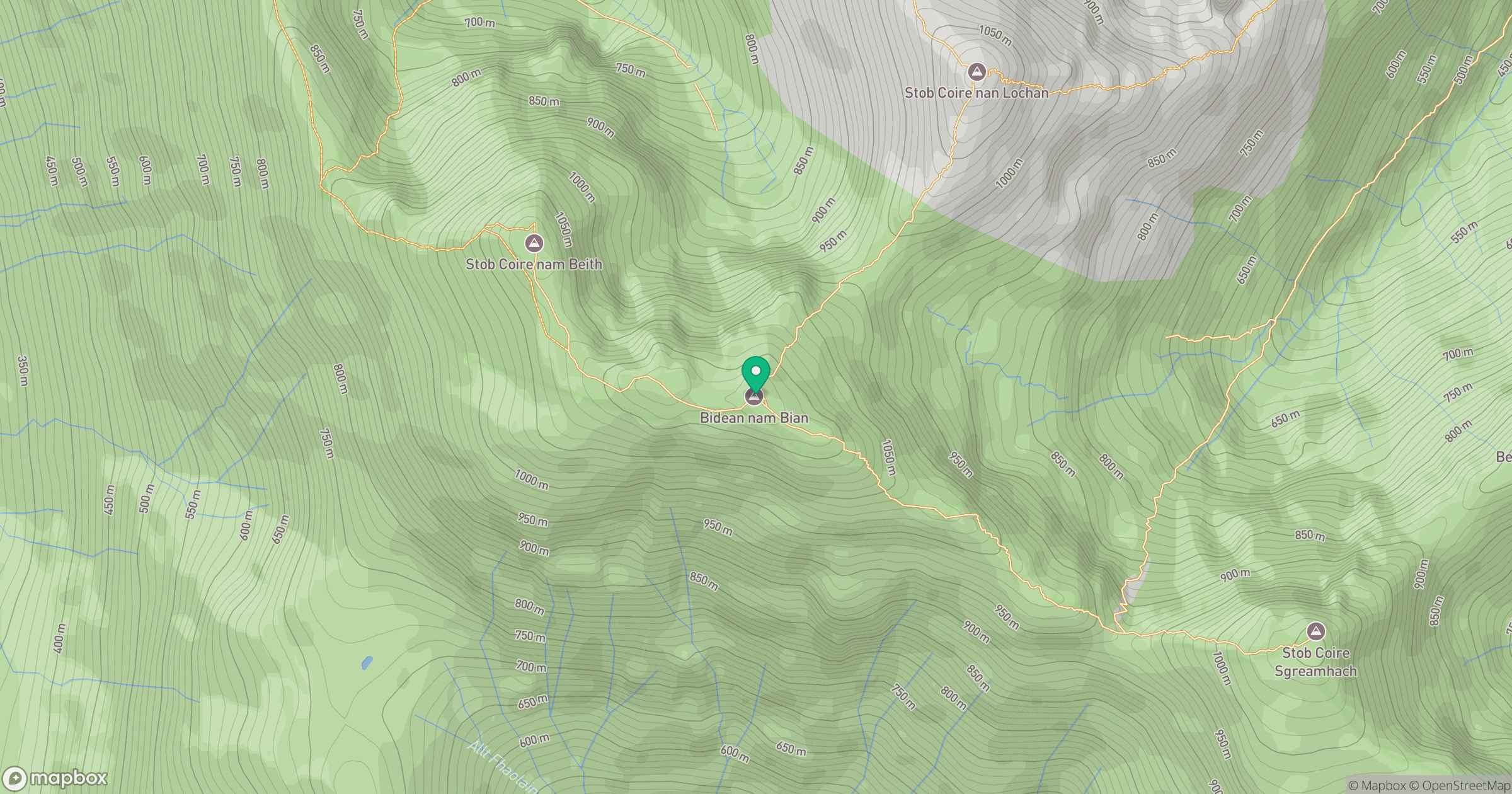
Grid reference: NN143542
View on OpenStreetMapOpens a map in a new tab, centred on the hill.
No comments yet. Be the first.