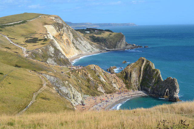
Le Moulin (Sark)

Le Moulin (Sark)

Le Moulin (Sark) Group Walks | Join a Walk

109m Elevation
109m Prominence
C Country

Join group walks, find walking companions and friends, or organise your own!

Classifications

Hump 100-199m Tump SIB

Looking for walking companions?

Don't walk alone! Find friendly walkers to explore Le Moulin (Sark) together. Join scheduled group walks or start your own.

Elevation

109m

358 ft

Prominence

109m

Coordinates

49.4312, -2.3624

WV462755

At the Summit

The summit features a small rocky outcrop adorned with wildflowers, and a stunning view of the English Channel and neighbouring islands.

Terrain & Geology

Rocky and grassy with some steep sections near the top.

The island features a mix of granite and schist rocks formed during the late Precambrian, giving it a rugged and picturesque landscape.

Views & Scenery

From the summit, you can see Guernsey to the east, Herm Isle, and the vast azure waters of the English Channel.

History & Heritage

Name Origin

Le Moulin means 'The Mill' in French, reflecting the historical agriculture of the island.

Historical Significance

Sark has a rich history as a feudal island and is known for its dark skies, making it a prime location for stargazing.

Popular Routes

Le Moulin Trail

Moderate

A scenic loop that takes you through the wooded areas and along the cliffs offering stunning views of the surrounding sea.

5 km 1.5 hours

Getting There & Facilities

Parking

There is limited parking available in the village of Sark, approximately 15 minutes walk from the trailhead.

Public Transport

Access to Sark is primarily by ferry from Guernsey. The nearest regular public transport links are on Guernsey.

Nearby Facilities

Sark has a few cafés and small shops; toilets are available in the village area.

Safety Information

Known Hazards

  • Poor weather can lead to sudden fog; always check the forecast before you set off.

General Safety Tips

  • Check weather conditions before setting out
  • Carry appropriate clothing and equipment
  • Let someone know your planned route
  • Take a map, compass, and GPS device
  • Carry emergency supplies: food, water, first aid kit, torch

Find Walking Companions

Join friendly walkers exploring Le Moulin (Sark) and surrounding area

Can't find a walk? Organise your own!

Create a walk and let others join you. It's free and easy!

Hills

Some common questions about the hills answered

Are there group walks up Le Moulin (Sark)?

Many walkers use Walkmates to join or organise walks with others. You can check for group walks around Le Moulin (Sark) through the maps

Are there other walkers around Le Moulin (Sark)?

Activity varies by location and time, but Walkmates lets you see whether others have shared walks or shown interest in this area. Find other people through the walking friends search walking friends for Le Moulin (Sark) search or of course create your own walk for Le Moulin (Sark)

Can I organise a walk to Le Moulin (Sark)?

Yes. If there aren’t any walks listed already, you can create a walk and make it available for others to join.

If you're signed up to Walkmates, you can create a walk to Le Moulin (Sark).

How do I find a walk up this hill?

There are often multiple ways to walk this hill, depending on experience and route preference. Walkmates helps you explore walks and routes that others have shared.

Can I suggest a new route up Le Moulin (Sark)?

Yes. You can suggest or create routes to share with others. Walkmates focuses on the social side of walking, so routes are used to help people organise walks and explore areas together, rather than as detailed navigation tools or route libraries.

Other uses really appreciate knowledgeable walkers sharing their routes. Share your favourite route to Le Moulin (Sark) here

The is an error or something incorrect about this hill. How do I let you know?

We always strive to keep the information on Walkmates as accurate as possible. If you find an error, please let us know through the contact form and we'll aim to correct it as quickly as possible