
Great Doward
Good walks are even better shared.
Overview
Great Doward: A Hidden Gem in the Wye Valley
Overview
Nestled in the charming Wye Valley, Great Doward stands as a testament to the stunning natural beauty of the region. With an elevation of 225 meters, it may not be the tallest, but it certainly packs a punch with its dramatic views and interesting geological features.
Geology
The limestone that forms Great Doward is a treasure trove for geology enthusiasts, filled with fossils from an era when the area was covered by warm, shallow seas. If you fancy fossil hunting, just keep your eyes peeled—but no 'rock splitting' necessary here!
Routes and Access
The Doward's View Loop is a favourite amongst locals and visitors alike. Starting from Whitchurch, this 5 km trail takes approximately 2 hours, with some moderate inclines that will have your legs singing (or perhaps complaining) by the end.
Parking can be a bit of a challenge due to limited spaces, so you might have to engage in a little bit of creative parking—just don’t block anyone’s driveway! Public transport is available, making it even easier to reach this natural wonder.
Summit Features
At the top, a stone cairn welcomes you, along with a trig point that’s perfect for a victory photograph. Just make sure you catch your breath before snapping the shot—no one looks good gasping!
Terrain and Hazards
The terrain is mostly grassy with a hint of rocky fun. However, it can get slippery, particularly after a good rain. As they say, what goes up must eventually come down—preferably without any spills!
Views
The breathtaking vistas take in the serene River Wye and the lush green hills beyond. For a truly stunning experience, visit in spring when the flora is in full bloom or in autumn for that classic leaf-changing spectacle.
Facilities
While there are no facilities on the mountain, the welcoming village of Whitchurch is just a short distance away, with a delightful café and local shop to replenish your energy.
Conclusion
Great Doward may be small, but it’s full of charm and adventure. Whether you’re a seasoned hiker or just looking for a pleasant stroll, it’s a marvellous spot to immerse yourself in nature’s embrace. So lace up those hiking boots and let the adventure begin!
Last updated: 2023-10-10
Explore routes near Great Doward
Walks starting near this hill. Open a route to check its map, distance and full itinerary.
Forest of Dean Hicksters Way Woodland Circuit from Cannop
View route
Forest of Dean Full Colliers Trail from Cannop Ponds
View route
Clytha Estate: River Usk, Chapel Ruins and Castle Woods
View route
Hereford Walk with Men Walking & Talking
View route
Route planning notes
These notes describe possible approaches. Check a route's map and access information when planning your walk.
Doward's View Loop
A popular circular walk starting from the historic village of Whitchurch. The route features stunning views over the River Wye and incorporates sections of the Offa's Dyke Path.
Make a day of it, together
Find someone to share the walk with, or organise a day out along a route you like.
Hill facts and local notes
Classifications
Elevation
201m
659 ft
Prominence
83m
Coordinates
51.8447, -2.6565
SO548164
OS Map
162
Explorer: OL14W
At the Summit
The summit is adorned with a stone cairn and offers an impressive trig point that serves as a perfect spot for a selfie against the backdrop of stunning views.
Terrain & Geology
Great Doward is primarily composed of limestone, which is quite prevalent in the Wye Valley area. The rock formations here are rich in fossils, dating back to the Carboniferous period, offering a glimpse into an ancient marine environment.
Views & Scenery
From the summit, you can enjoy panoramic views of the River Wye, the rolling hills of the Forest of Dean, and the distant Cotswolds; a sight that makes you feel on top of the world—or at least on top of a very nice hill.
History & Heritage
Name Origin
The name 'Doward' is thought to derive from an old Welsh term related to the landscape, possibly meaning 'hill' or 'mountain'.
Historical Significance
The area has historical importance as part of the ancient Offa's Dyke, formed as a boundary in 8th century England, and has been a favourite amongst walkers for generations.
Getting There & Facilities
Parking
There is limited parking available at the Whitchurch village hall or in the nearby laybys.
Public Transport
The nearest bus stop is in Whitchurch, serviced by local services from Monmouth and surrounding areas.
Nearby Facilities
There are no facilities on the hill itself, but the quaint village of Whitchurch offers a local shop and a lovely café for refreshments before or after your hike.
Safety Information
Known Hazards
- The terrain can be slippery after rain, so watch your step. Additionally, be aware of steep drops near some of the unmarked paths.
General Safety Tips
- Check weather conditions before setting out
- Carry appropriate clothing and equipment
- Let someone know your planned route
- Take a map, compass, and GPS device
- Carry emergency supplies: food, water, first aid kit, torch
Hills
Some common questions about the hills answered
Are there group walks up Great Doward?
Many walkers use Walkmates to join or organise walks with others. You can check for group walks around Great Doward through the maps
Are there other walkers around Great Doward?
Activity varies by location and time, but Walkmates lets you see whether others have shared walks or shown interest in this area. Find other people through the walking friends search walking friends for Great Doward search or of course create your own walk for Great Doward
Can I organise a walk to Great Doward?
Yes. If there aren’t any walks listed already, you can create a walk and make it available for others to join.
If you're signed up to Walkmates, you can create a walk to Great Doward.
How do I find a walk up this hill?
There are often multiple ways to walk this hill, depending on experience and route preference. Walkmates helps you explore walks and routes that others have shared.
Can I suggest a new route up Great Doward?
Yes. You can suggest or create routes to share with others. Walkmates focuses on the social side of walking, so routes are used to help people organise walks and explore areas together, rather than as detailed navigation tools or route libraries.
Other uses really appreciate knowledgeable walkers sharing their routes. Share your favourite route to Great Doward here
The is an error or something incorrect about this hill. How do I let you know?
We always strive to keep the information on Walkmates as accurate as possible. If you find an error, please let us know through the contact form and we'll aim to correct it as quickly as possible
Community Discussion
Comments
Location
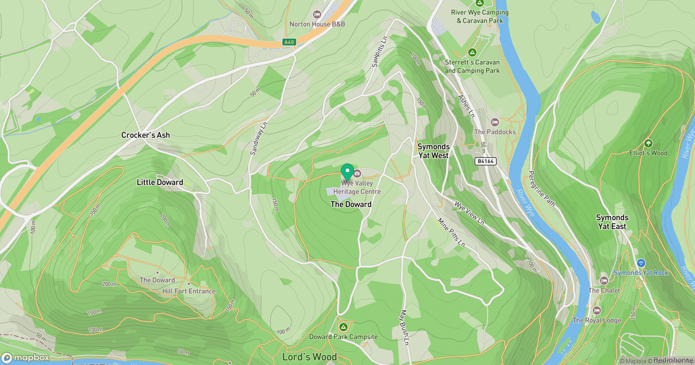
Grid reference: SO548164
View on OpenStreetMapOpens a map in a new tab, centred on the hill.
Nearby Hills
Worcestershire Beacon
425m
Titterstone Clee Hill
533m
Glastonbury Tor
158m
Long Mynd - Pole Bank
517m

Cribyn
794m
No comments yet. Be the first.