

Finsthwaite Heights
Good walks are even better shared.
SD3688 : Evening over Furness Fells
Simon Barnes Photo source
Overview
Finsthwaite Heights: A Hiker's Delight
Nestled in the heart of the Lake District, Finsthwaite Heights offers a refreshing escape for hikers looking to explore lesser-known trails without sacrificing the beauty the region is famous for. With its moderate elevation of 226 meters, it may not be the tallest in the area, but it certainly holds its own in terms of splendour.
Geology
Finsthwaite Heights is primarily composed of andesite, a volcanic rock that testifies to the region's fiery past. As you hike through its rocky terrains, you’ll encounter snippets of these ancient formations that catch the sunlight just right, showcasing the vibrant textures of the landscape.
Routes
The main route starting from Finsthwaite Village is well-marked and friendly for walkers of various abilities. At around 5 km in length, you can complete this pleasant jaunt in approximately 2.5 hours, depending on how often you stop to snap pictures of those jaw-dropping views.
Summit Features
Upon reaching the summit, you will be greeted by a modest cairn that stands testament to many a hiker's journey. The panoramic vistas are breathtaking, with sweeping views of Windermere and the southern fells you won’t want to miss. Make sure you catch a sunset here; you won’t regret it!
Terrain
The terrain is a delightful mix of grassy slopes and rocky outcrops, interspersed with a few boggy patches to keep things interesting. Wear sturdy footwear — you’ll thank yourself later when you don’t end up boot-deep in mud!
Views
From the summit, not only do you get a fantastic view of Windermere, but on clear days, you can also gaze towards the Yorkshire Dales, making it a perfect viewing platform for our fine British landscapes. Spring and autumn are particularly magical, so choose your time wisely.
Hazards
While the trails are generally safe, do take care of wet paths, especially after rainfall. Keep an eye out for sheep who might be more interested in your sandwich than letting you pass!
Access
Finsthwaite Village serves as the gateway to the heights, with a small parking area. When visiting, be kind to the locals by parking considerately. If you prefer public transport, head to Windermere station and hop onto a local bus.
Facilities
While the heights themselves are devoid of facilities, Finsthwaite Village will welcome you with a café and a public toilet. A perfect way to recharge after a day of adventure.
History
The name Finsthwaite rolls off the tongue with a quaint charm, meaning 'clearing'. It hints at a history of settlers finding their way amidst the woodland. This mountain has seen many stories unfold, steeped in the folklore of the area.
In conclusion, Finsthwaite Heights is a delightful choice for a day out in the Lake District. Whether you're a seasoned hiker or a casual walker, the heights offer a mix of scenic beauty, rich history, and a touch of adventure. Just remember to bring your camera — the views here are Instagram gold!
Explore routes near Finsthwaite Heights
Walks starting near this hill. Open a route to check its map, distance and full itinerary.
Grizedale: Silurian Way walking trail
View route
Windermere west shore: Ash Landing to Wray and back
View route
Coniston to Tarn Hows: Monk Coniston Gardens and Woodland Circuit
View route
Tarn Hows Fast Route
View route
Route planning notes
These notes describe possible approaches. Check a route's map and access information when planning your walk.
Finsthwaite Village to Summit
This well-trodden route begins in the quaint village of Finsthwaite, leading hikers through lush woodlands before ascending towards the summit, offering a gradual climb suitable for most abilities.
Make a day of it, together
Find someone to share the walk with, or organise a day out along a route you like.
Photo Gallery
View all Photo could not load
SD3688 : Evening over Furness Fells
Simon Barnes
Hill facts and local notes
Classifications
Elevation
180m
591 ft
Prominence
0m
Coordinates
54.2870, -2.9832
SD360883
OS Map
96 97
Explorer: OL7S
At the Summit
The summit is crowned with a modest cairn and offers a panoramic view of the surrounding hills and valleys. Don’t forget to stop for a selfie; your followers will thank you!
Terrain & Geology
Primarily composed of volcanic rocks known as andesite, Finsthwaite Heights features distinctive geological formations formed during volcanic activity that once covered the area millions of years ago.
Views & Scenery
The stunning vistas include glimpses of Windermere, the largest lake in England, and the southern fells of the Lake District. On a clear day, you might even spot the rolling hills of the Yorkshire Dales to the east.
History & Heritage
Name Origin
The name 'Finsthwaite' derives from the Old Norse words 'finna' meaning 'to find' and 'thwaite' meaning 'clearing', indicating a historic site of settled land amidst dense woodland.
Historical Significance
Finsthwaite Heights has been a part of the local culture for centuries, often referenced in folk tales and memories of old, making it a cherished landmark among locals.
Getting There & Facilities
Parking
Finsthwaite Village offers a small parking area, but it’s best to arrive early to secure a space. Local residents appreciate visitors who are mindful of parking restrictions.
Public Transport
The nearest train station is in Windermere, from where local buses operate to Finsthwaite. Schedule your ride wisely, as services may be limited.
Nearby Facilities
There are no formal facilities on the mountain itself, but the nearby village has a café and public toilets for those in need of a pit stop.
Safety Information
Known Hazards
- Beware of wet and slippery paths, especially in winter and after heavy rain. Also, keep an eye out for sheep — they have a knack for blocking paths!
General Safety Tips
- Check weather conditions before setting out
- Carry appropriate clothing and equipment
- Let someone know your planned route
- Take a map, compass, and GPS device
- Carry emergency supplies: food, water, first aid kit, torch
Hills
Some common questions about the hills answered
Are there group walks up Finsthwaite Heights?
Many walkers use Walkmates to join or organise walks with others. You can check for group walks around Finsthwaite Heights through the maps
Are there other walkers around Finsthwaite Heights?
Activity varies by location and time, but Walkmates lets you see whether others have shared walks or shown interest in this area. Find other people through the walking friends search walking friends for Finsthwaite Heights search or of course create your own walk for Finsthwaite Heights
Can I organise a walk to Finsthwaite Heights?
Yes. If there aren’t any walks listed already, you can create a walk and make it available for others to join.
If you're signed up to Walkmates, you can create a walk to Finsthwaite Heights.
How do I find a walk up this hill?
There are often multiple ways to walk this hill, depending on experience and route preference. Walkmates helps you explore walks and routes that others have shared.
Can I suggest a new route up Finsthwaite Heights?
Yes. You can suggest or create routes to share with others. Walkmates focuses on the social side of walking, so routes are used to help people organise walks and explore areas together, rather than as detailed navigation tools or route libraries.
Other uses really appreciate knowledgeable walkers sharing their routes. Share your favourite route to Finsthwaite Heights here
The is an error or something incorrect about this hill. How do I let you know?
We always strive to keep the information on Walkmates as accurate as possible. If you find an error, please let us know through the contact form and we'll aim to correct it as quickly as possible
Community Discussion
Comments
Location
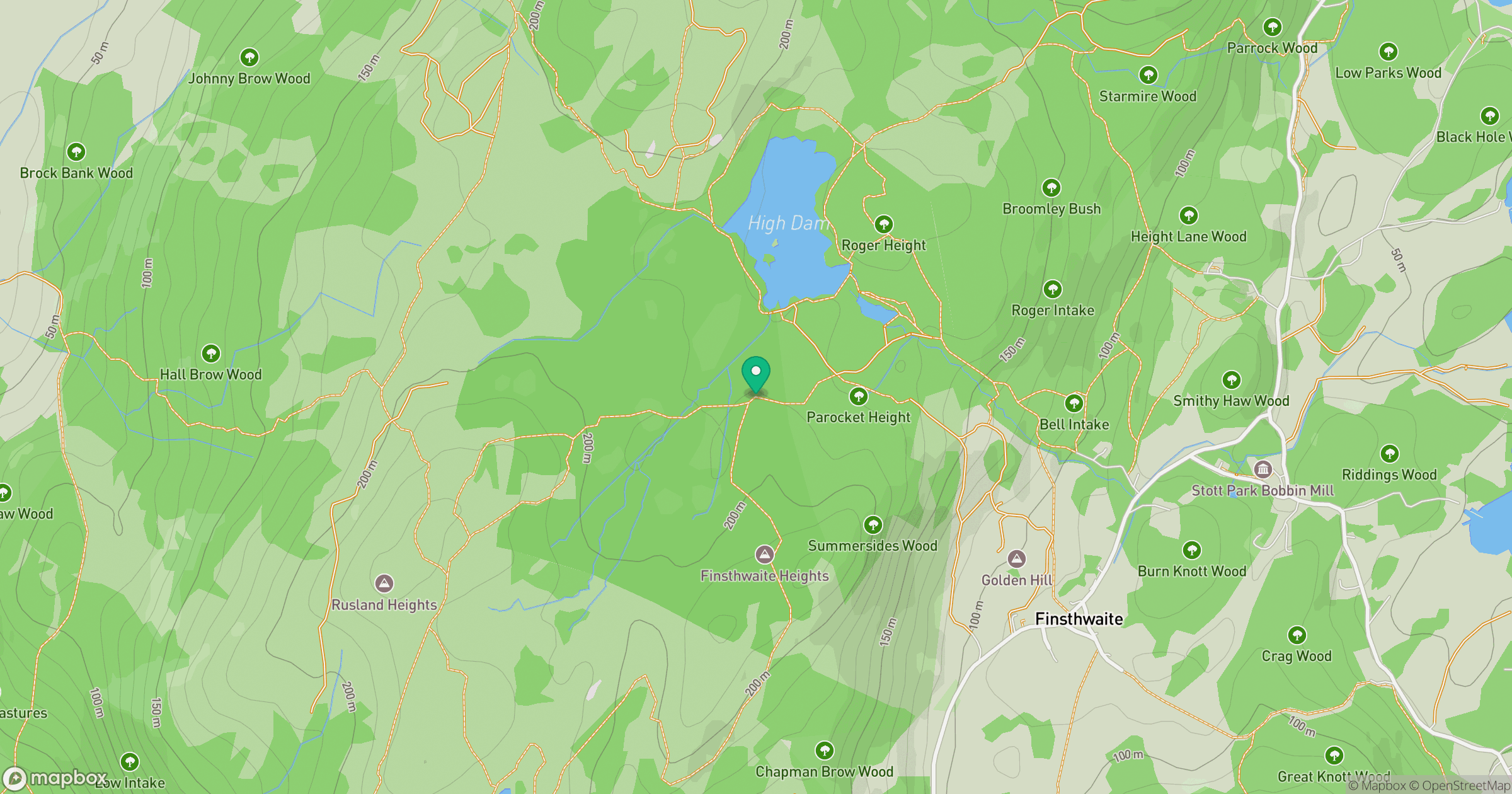
Grid reference: SD360883
View on OpenStreetMapOpens a map in a new tab, centred on the hill.

No comments yet. Be the first.