
Milharay Hill
Good walks are even better shared.
Overview
Overview
Milharay Hill stands proudly in the Lake District, offering both breathtaking views and a challenging but doable hike. At 421 meters, it's not the tallest of hills, but its steep ascent and rocky terrain can catch even the most seasoned hiker off guard!
Geology
The fascinating geology of Milharay Hill draws keen geologists and curious hikers alike. The volcanic rock that comprises the hill hints at its fiery origins millions of years ago, layered beneath the scenic greenery that now dominates the landscape.
Hiking Routes
The primary route up Milharay Hill begins at Scalebar Foot. Spanning approximately 5 km, this route is moderate in difficulty and can typically be tackled in about 2.5 hours. Hikers will wind through beautifully green valleys, occasionally tripping over the odd stone or two while keeping an eye out for rogue sheep.
Summit Features
Reaching the summit is a reward in itself, crowned with a quaint stone cairn that seems to have been placed there specifically for your photo opportunity! Have a breather and enjoy a sandwich as the magnificent views unfold.
Terrain
The terrain is a mix of rocky paths and grassy fields. However, do tread carefully, as parts of the route can turn boggy. Waterproof boots are definitely your best friend on the ascent, especially in wetter months!
Views
On a clear day, the views from Milharay Hill are simply unparalleled. Gaze across the rolling hills of the Lake District and spy Ullswater’s shimmering waters in the distance. Spring and early autumn provide the best visibility and scenery.
Hazards
Keep your wits about you: loose stones, boggy patches, and unexpected weather can add excitement (or trepidation) to your hike! It’s wise to carry a map and proper gear to ensure you're well-prepared for all eventualities.
Access
Reaching Milharay Hill is straightforward. The nearest parking is at Scalebar Foot, though spots can fill up rather quickly on weekends. Public transport is available via bus from Penrith, leading you to Glenridding, your closest town for post-hike refreshments.
Facilities
After your hike, treat yourself at one of the local cafés or pubs in Glenridding. Restrooms are also available, as nobody enjoys a hike being cut short for lack of facilities!
History
The name 'Milharay' is believed to mean 'hill of the foolish'. Perhaps a fitting title for those who forget their lunch! The hill is steeped in folklore, often linked to tales of lost treasures and local legends.
Enjoy your journey up Milharay Hill, and may the wind be ever at your back!
Explore routes near Milharay Hill
Walks starting near this hill. Open a route to check its map, distance and full itinerary.
Castle Douglas Carlingwark Loch and Lover’s Walk Circuit
View route
Threave Nature Reserve River Dee Circuit
View route
Dalbeattie Forest Plantain Loch Trail
View route
Mabie Forest Dalshinnie Glen and Loch
View route
Route planning notes
These notes describe possible approaches. Check a route's map and access information when planning your walk.
Start at Scalebar Foot
A scenic route from Scalebar Foot leading up through lush valleys and rocky paths to the summit.
Make a day of it, together
Find someone to share the walk with, or organise a day out along a route you like.
Hill facts and local notes
Classifications
Elevation
299m
982 ft
Prominence
61m
Coordinates
55.0504, -3.8798
NX800744
OS Map
84
Explorer: 313 320 321
At the Summit
The summit features a classic stone cairn along with fantastic panoramic views, providing the perfect spot for a well-earned sandwich.
Terrain & Geology
Milharay Hill is primarily composed of volcanic rock, a remnant of ancient eruptions that shaped this rugged landscape. The hill's formation dates back millions of years, making the geology not just interesting but practically dinosaur-approved!
Views & Scenery
From the summit, hikers can see the impressive peaks of the nearby Pennines and sweeping views of the Lake District, including Ullswater in the distance.
History & Heritage
Name Origin
The name 'Milharay' is believed to derive from Old Norse, translating to 'hill of the foolish', which should make for an entertaining conversation starter on your trek!
Historical Significance
Milharay Hill is significant in local mythology and folklore, often associated with tales of ancient sheep herders and lost treasures.
Getting There & Facilities
Parking
Parking is available at Scalebar Foot, a small car park with space for around 15 vehicles—arrive early on weekends to snatch a spot!
Public Transport
The nearest public transport can be accessed from Penrith, with buses that run to the nearby village of Patterdale.
Nearby Facilities
Facilities include several cafés and pubs in Glenridding, offering refreshments post-hike, as well as public toilets.
Safety Information
Known Hazards
- Beware of loose stones on the path and boggy ground, particularly after rain. Sudden weather changes can also catch you unawares!
General Safety Tips
- Check weather conditions before setting out
- Carry appropriate clothing and equipment
- Let someone know your planned route
- Take a map, compass, and GPS device
- Carry emergency supplies: food, water, first aid kit, torch
Hills
Some common questions about the hills answered
Are there group walks up Milharay Hill?
Many walkers use Walkmates to join or organise walks with others. You can check for group walks around Milharay Hill through the maps
Are there other walkers around Milharay Hill?
Activity varies by location and time, but Walkmates lets you see whether others have shared walks or shown interest in this area. Find other people through the walking friends search walking friends for Milharay Hill search or of course create your own walk for Milharay Hill
Can I organise a walk to Milharay Hill?
Yes. If there aren’t any walks listed already, you can create a walk and make it available for others to join.
If you're signed up to Walkmates, you can create a walk to Milharay Hill.
How do I find a walk up this hill?
There are often multiple ways to walk this hill, depending on experience and route preference. Walkmates helps you explore walks and routes that others have shared.
Can I suggest a new route up Milharay Hill?
Yes. You can suggest or create routes to share with others. Walkmates focuses on the social side of walking, so routes are used to help people organise walks and explore areas together, rather than as detailed navigation tools or route libraries.
Other uses really appreciate knowledgeable walkers sharing their routes. Share your favourite route to Milharay Hill here
The is an error or something incorrect about this hill. How do I let you know?
We always strive to keep the information on Walkmates as accurate as possible. If you find an error, please let us know through the contact form and we'll aim to correct it as quickly as possible
Community Discussion
Comments
Location
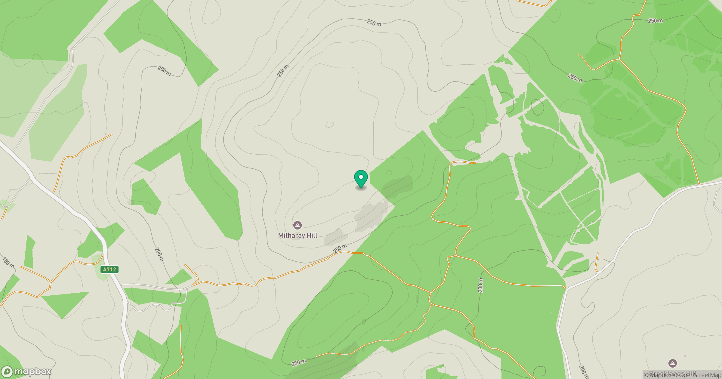
Grid reference: NX800744
View on OpenStreetMapOpens a map in a new tab, centred on the hill.

No comments yet. Be the first.