

Mardale Ill Bell
Good walks are even better shared.
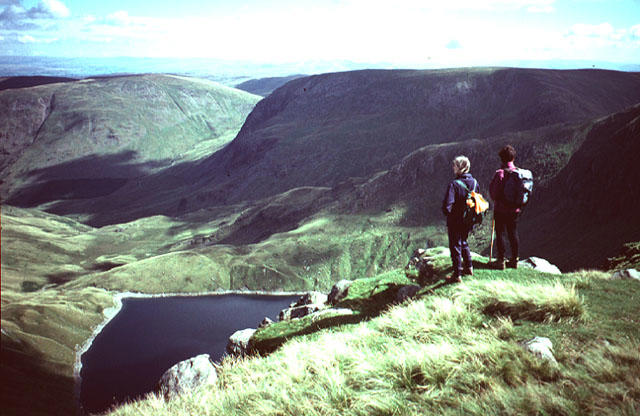
NY4410 : Tarn on Mardale Ill Bell
Graham Robson Photo source
Overview
Mardale Ill Bell: A Hiker's Delight
Mardale Ill Bell is a commanding presence in the Lake District, standing tall with an elevation of 800 meters. Known for its rugged terrain and stunning vistas, it is a favourite among seasoned hikers and casual walkers alike.
Geology
The mountain is mainly formed of Skiddaw slate, an ancient rock that has weathered the test of time. This geological composition gives hikers the chance to marvel at the wonders of nature while trudging along the pathways.
Routes
The routes to Mardale Ill Bell are as varied as the scenery you will encounter. One popular option is the trail from Harter Fell, which offers an enjoyable combination of ascent and fabulous views. Alternatively, many choose to start at Nan Bield Pass, creating a well-rounded experience that includes the beauty of both access points.
Summit Features
As you reach the summit, you will be greeted by a stone cairn that serves as both a landmark and a place for reflection. Don’t forget to snap that summit selfie—because if you don’t post it on social media, did you even climb it?
Terrain Type
Expect a mix of rocky pathways and grassy knolls, with a few boggy patches thrown in for good measure. The Lake District is notorious for its unpredictable weather, so pack accordingly and remember, a little mud never hurt anyone!
Views
The views from Mardale Ill Bell are nothing short of spectacular. With Haweswater stretching out before you and other peaks like Harter Fell and High Street standing proud in the distance, it’s the kind of sight that makes the climb worth every step. If you aim to catch the sunset, just make sure you leave enough time for the descent—it would be a shame to miss dinner!
Hazards
While the hike is moderately challenging, it’s essential to watch your step. Loose rocks and tricky bogs can catch you off balance, so having a steady foot is crucial. Always follow marked paths to avoid any getting lost in the hills!
Access
Getting to Mardale Ill Bell is straightforward, with parking available near the village of Mardale. However, do plan to arrive early to nab a spot, especially during peak hiking seasons—nobody likes to hike with a heavy heart (or a heavy car!). Public transport options are limited, so if you're planning to rely on buses, do double-check schedules.
Facilities
Facilities are limited around Mardale, but Bampton has a lovely café where you can refuel after your hike. Worth considering is packing a lunch to enjoy at the summit surrounded by nature's beauty!
History
The name ‘Mardale’ speaks to the valley’s past, derived from Old Norse, while ‘Ill Bell’ adds a touch of drama to the mountain’s character. This peak has played a significant role in the heritage of the Lake District, drawing visitors eager to explore its enchanting landscape.
Mardale Ill Bell, with its stunning views, challenging routes, and rich history, promises to be an unforgettable adventure. Whether you're a seasoned mountaineer or a casual walker, this mountain beckons like a perfectly brewed cup of tea—you simply can't resist!
Explore routes near Mardale Ill Bell
Walks starting near this hill. Open a route to check its map, distance and full itinerary.
Striding Edge, Helvellyn and Catstye Cam
View route
Helvellyn via Striding Edge
View route
Windermere west shore: Ash Landing to Wray and back
View route
Tarn Hows Fast Route
View route
Route planning notes
These notes describe possible approaches. Check a route's map and access information when planning your walk.
Harter Fell to Mardale Ill Bell
A scenic route that connects Harter Fell with Mardale Ill Bell, offering stunning views and a chance to spot local wildlife.
Nan Bield Pass
A popular starting point that leads across the stunning Nan Bield Pass, merging into a well-trodden path to the summit.
Make a day of it, together
Find someone to share the walk with, or organise a day out along a route you like.
Photo Gallery
View all Photo could not load
NY4410 : Tarn on Mardale Ill Bell
Graham Robson
 Photo could not load
NY4410 : Tarn on Mardale Ill Bell
Anthony Foster
 Photo could not load
NY4410 : From Mardale Ill Bell
Michael Graham
 Photo could not load
NY4410 : Mardale Ill Bell Summit
Shaun Ferguson
 Photo could not load
NY4410 : Cairn on the approach to Mardale Ill Bell
Anthony Foster
 Photo could not load
NY4410 : Small tarn on High Street
Tom Richardson
 Photo could not load
NY4410 : En route from High Street towards Mardale Ill Bell & Harter Fell
Colin Park
 Photo could not load
NY4410 : Frozen puddle on Mardale Ill Bell
Bill Boaden
 Photo could not load
NY4410 : Small tarn on Mardale Ill Bell
Alan O'Dowd

NY4410 : Summit Cairn, Mardale Ill Bell
Michael Graham
Hill facts and local notes
Classifications
Elevation
760m
2,493 ft
Prominence
13m
Coordinates
54.4834, -2.8541
NY447101
OS Map
90
Explorer: OL5S OL7N
At the Summit
The summit features a small stone cairn and offers a panoramic view that makes the climb absolutely worthwhile. Just don't forget to take your picture - or it didn’t happen!
Terrain & Geology
Mardale Ill Bell is primarily composed of Skiddaw slate, a product of ancient sedimentary deposits compressed over millions of years. This slate gives the mountain its rugged appearance and provides fascinating geological features to explore.
Views & Scenery
From the summit, one can see the expansive waters of Haweswater, the majestic peaks of the surrounding fells, including Harter Fell and High Street, as well as distant views of the Yorkshire Dales.
History & Heritage
Name Origin
The name 'Mardale' translates from Old Norse to 'valley with a lake', hinting at its picturesque setting. 'Ill Bell' may refer to its dramatic landscape.
Historical Significance
Mardale Ill Bell is well-loved among hikers and has been frequented by outdoor enthusiasts for generations, symbolising the natural beauty of the Lake District.
Getting There & Facilities
Parking
Parking is available at the small car park near the village of Mardale, which leads directly to the foot of the mountain. However, get there early, as spaces are limited!
Public Transport
The nearest bus route is from Kendal to Bampton via the 560 service, though it is advisable to check local schedules.
Nearby Facilities
There are limited amenities in Bampton, including a café and a public toilet. Be sure to bring your own snacks as the mountain won’t be serving any!
Safety Information
Known Hazards
- Beware of loose rocks in places and boggy sections that may be slippery, especially after rain. Always stick to marked paths to avoid getting lost!
General Safety Tips
- Check weather conditions before setting out
- Carry appropriate clothing and equipment
- Let someone know your planned route
- Take a map, compass, and GPS device
- Carry emergency supplies: food, water, first aid kit, torch
Hills
Some common questions about the hills answered
Are there group walks up Mardale Ill Bell?
Many walkers use Walkmates to join or organise walks with others. You can check for group walks around Mardale Ill Bell through the maps
Are there other walkers around Mardale Ill Bell?
Activity varies by location and time, but Walkmates lets you see whether others have shared walks or shown interest in this area. Find other people through the walking friends search walking friends for Mardale Ill Bell search or of course create your own walk for Mardale Ill Bell
Can I organise a walk to Mardale Ill Bell?
Yes. If there aren’t any walks listed already, you can create a walk and make it available for others to join.
If you're signed up to Walkmates, you can create a walk to Mardale Ill Bell.
How do I find a walk up this hill?
There are often multiple ways to walk this hill, depending on experience and route preference. Walkmates helps you explore walks and routes that others have shared.
Can I suggest a new route up Mardale Ill Bell?
Yes. You can suggest or create routes to share with others. Walkmates focuses on the social side of walking, so routes are used to help people organise walks and explore areas together, rather than as detailed navigation tools or route libraries.
Other uses really appreciate knowledgeable walkers sharing their routes. Share your favourite route to Mardale Ill Bell here
The is an error or something incorrect about this hill. How do I let you know?
We always strive to keep the information on Walkmates as accurate as possible. If you find an error, please let us know through the contact form and we'll aim to correct it as quickly as possible
Community Discussion
Comments
Location
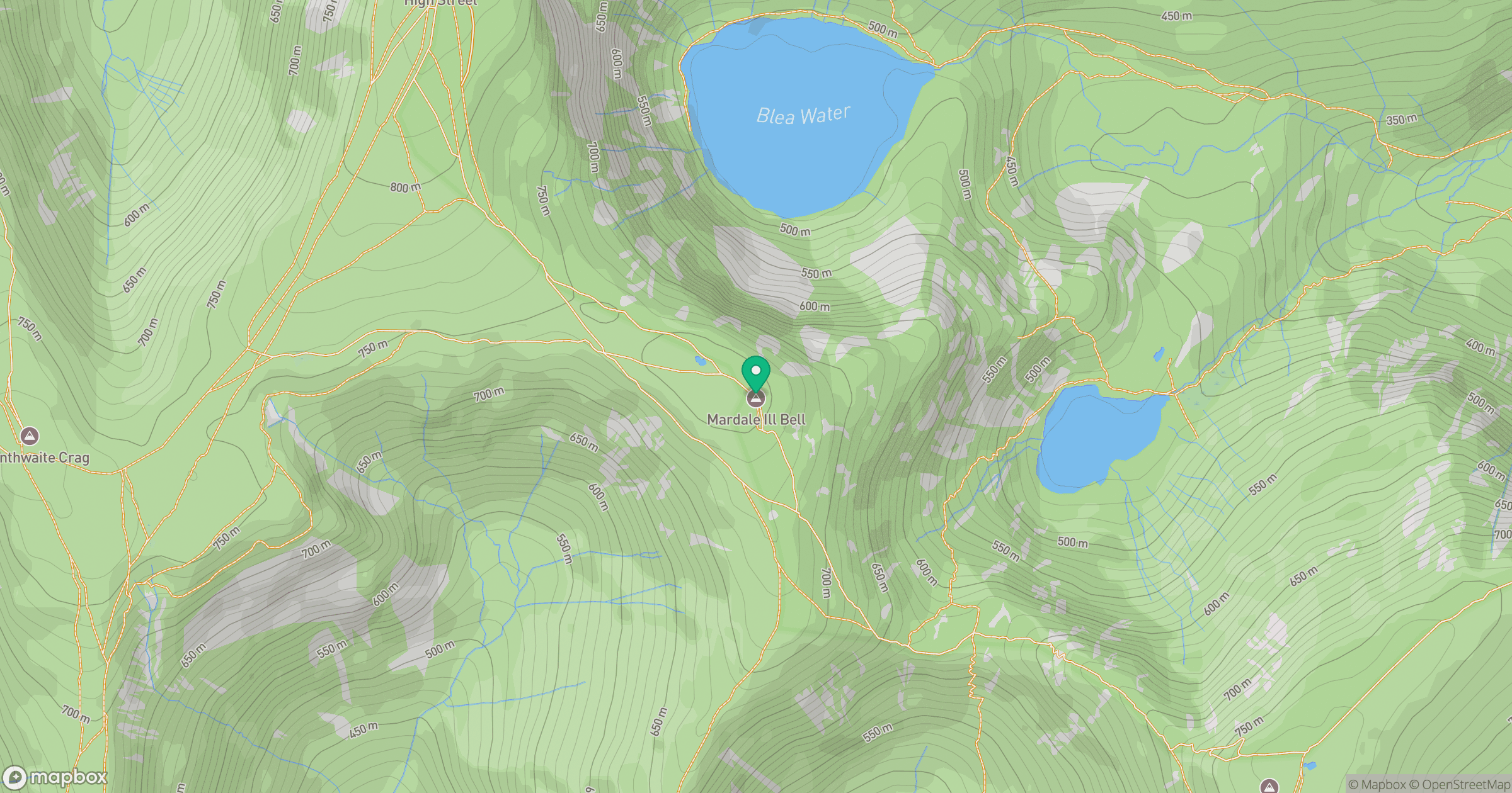
Grid reference: NY447101
View on OpenStreetMapOpens a map in a new tab, centred on the hill.
No comments yet. Be the first.