

Binn na Tine [Sybil Point]
Good walks are even better shared.
Q3106 : Ceann Sibeal - Sybil Point
Peter Church Photo source
Explore routes near Binn na Tine [Sybil Point]
Walks starting near this hill. Open a route to check its map, distance and full itinerary.
Route planning notes
These notes describe possible approaches. Check a route's map and access information when planning your walk.
Binn na Tine Loop Trail
A rewarding circular route that offers panoramic views of the coastal landscape with various ascents and descents along the way.
Make a day of it, together
Find someone to share the walk with, or organise a day out along a route you like.
Photo Gallery
View all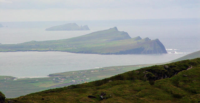 Photo could not load
Q3106 : Ceann Sibeal - Sybil Point
Peter Church
Hill facts and local notes
Classifications
Elevation
205m
673 ft
Prominence
198m
Coordinates
52.1835, -10.4651
Q314063
OS Map
70
At the Summit
At the summit, hikers will find a small stone cairn and a trig point, both offering excellent photo opportunities against the backdrop of the North Atlantic.
Terrain & Geology
The peak is mainly composed of basalt and limestone, formed during the volcanic activity associated with the Antrim Lava Group. This unique geology creates stunning cliff formations and gives rise to an array of flora and fauna.
Views & Scenery
From the summit, expect to see the sweeping landscapes of the Antrim coastline, Rathlin Island, and the majestic Scottish Isles off in the distance.
History & Heritage
Name Origin
Binn na Tine translates to 'Hill of the Fire', which is thought to refer to the ancient practices of fire signalling from the peak.
Historical Significance
The area is rich in folklore and local history, often associated with Gaelic myths and legends surrounding the Antrim coast.
Getting There & Facilities
Parking
The nearest parking is available at the Binn na Tine trailhead, marked on maps. A small area can accommodate several vehicles, but spaces may be limited during peak times.
Public Transport
Public transport is limited; however, local buses do service nearby villages like Ballycastle, from where a taxi can be organised to the trailhead.
Nearby Facilities
In Ballycastle, you can find various cafes, restaurants, and even toilet facilities. Don't miss out on the local fish and chips after your hike!
Safety Information
Known Hazards
- Watch for loose stones and sudden weather changes. It's wise to keep an eye on the forecast to avoid getting caught out in a downpour—or worse, a gale!
General Safety Tips
- Check weather conditions before setting out
- Carry appropriate clothing and equipment
- Let someone know your planned route
- Take a map, compass, and GPS device
- Carry emergency supplies: food, water, first aid kit, torch
Hills
Some common questions about the hills answered
Are there group walks up Binn na Tine [Sybil Point]?
Many walkers use Walkmates to join or organise walks with others. You can check for group walks around Binn na Tine [Sybil Point] through the maps
Are there other walkers around Binn na Tine [Sybil Point]?
Activity varies by location and time, but Walkmates lets you see whether others have shared walks or shown interest in this area. Find other people through the walking friends search walking friends for Binn na Tine [Sybil Point] search or of course create your own walk for Binn na Tine [Sybil Point]
Can I organise a walk to Binn na Tine [Sybil Point]?
Yes. If there aren’t any walks listed already, you can create a walk and make it available for others to join.
If you're signed up to Walkmates, you can create a walk to Binn na Tine [Sybil Point].
How do I find a walk up this hill?
There are often multiple ways to walk this hill, depending on experience and route preference. Walkmates helps you explore walks and routes that others have shared.
Can I suggest a new route up Binn na Tine [Sybil Point]?
Yes. You can suggest or create routes to share with others. Walkmates focuses on the social side of walking, so routes are used to help people organise walks and explore areas together, rather than as detailed navigation tools or route libraries.
Other uses really appreciate knowledgeable walkers sharing their routes. Share your favourite route to Binn na Tine [Sybil Point] here
The is an error or something incorrect about this hill. How do I let you know?
We always strive to keep the information on Walkmates as accurate as possible. If you find an error, please let us know through the contact form and we'll aim to correct it as quickly as possible
Community Discussion
Comments
Location
View the hill's mapped position and surrounding paths.
Grid reference: Q314063
View on OpenStreetMapOpens a map in a new tab, centred on the hill.
No comments yet. Be the first.