

Great Rigg
Good walks are even better shared.
Overview
Great Rigg
Great Rigg rises to 766.4 metres on the ridge south of Fairfield. Its grassy shoulders and rocky summit stand above Grasmere and the Rydal valley, making it a natural link between Stone Arthur, Heron Pike and the higher fells.
Summit and views
The substantial cairn is the familiar Wainwright top. The highest point is a rock about 15 metres north-east of it. From this part of the ridge, the outlook reaches towards the Coniston fells and the Helvellyn range, with Fairfield close to the north and the other arm of the horseshoe across Rydal.
Walking from Grasmere
A direct approach climbs from the north side of Grasmere towards Stone Arthur, then follows its ridge north-east to Great Rigg. The lower climb is steep, with stone steps and sections where summer bracken crowds the path. Higher up, scattered outcrops and wet hollows break up the grassy ridge.
For a circular day, continue south from Great Rigg over Heron Pike and Nab Scar, descend towards Rydal, and use the old coffin route back to Grasmere. This gives a full return rather than finishing at a different village. Another circuit approaches through Alcock Tarn and the Heron Pike ridge before descending by Stone Arthur.
Great Rigg also lies on the much longer Fairfield Horseshoe from Rydal or Ambleside. Continuing north to Fairfield adds high, exposed ground and a summit plateau where finding the correct way off can be difficult in mist. Choose a complete mapped circuit before setting out.
Terrain and conditions
This is a substantial fell walk, not a gentle village outing. Expect steep climbing and descent, rocky and eroded paths, and some damp ground. A clear path in sunshine can be much harder to follow in cloud, especially where ridges divide. Wind, snow and ice can change the character of the walk considerably.
Carry a map and compass, know how to use them, and allow enough daylight for the lower paths as well as the ridge. Keep to established paths through the enclosed land near Grasmere and take care at the A591 crossing.
Starting out
Grasmere has shops, cafés and public toilets. Broadgate Meadow and Stock Lane are pay-and-display parking options; follow the current signs for charges and payment. Leave lanes and entrances clear.
Check current bus services to Grasmere and the last return when planning a car-free walk. Take food, water and suitable mountain clothing with you rather than relying on facilities once you leave the village.
Explore routes near Great Rigg
Public walks starting within 80 km of this hill. Nearby does not mean a route reaches the summit; check its map and access before setting out.
Striding Edge, Helvellyn and Catstye Cam
View route
Helvellyn via Striding Edge
View route
Great Carrs Halifax Wreckage from Wrynose Pass
View route
Tarn Hows Fast Route
View route
Route planning notes
These notes describe possible approaches, not verified navigable routes or permission to cross land. Check current paths, local access rules and conditions before setting out.
Stone Arthur and the southern ridge circuit
From Grasmere climb via Stone Arthur to Great Rigg, then follow Heron Pike and Nab Scar down towards Rydal. Return to Grasmere by the coffin route. Plan the complete circuit.
Alcock Tarn and Stone Arthur circuit
From Grasmere approach through Alcock Tarn to the Heron Pike ridge and Great Rigg, returning by Stone Arthur. Use a complete mapped route that returns to your starting point.
Make a day of it, together
Find someone to share the walk with, or organise a day out along a route you like.
Photo Gallery
View all Photo could not load
NY3510 : Greatrigg Man - Summit Cairn
Anthony Parkes
 Photo could not load
NY3510 : The top of Great Rigg
Bill Boaden
 Photo could not load
NY3510 : View into the Rydal Beck valley
Philip Halling
 Photo could not load
NY3510 : The west slopes of Great Rigg
David Purchase
 Photo could not load
NY3510 : The summit of Great Rigg
Ian Greig
 Photo could not load
NY3510 : Great Rigg
Ian Greig
 Photo could not load
NY3510 : Footpath nearing Great Rigg
Shaun Ferguson
 Photo could not load
NY3510 : Embedded rocks at summit of Great Rigg
Trevor Littlewood
 Photo could not load
NY3510 : Lunch on Great Rigg
DS Pugh

NY3510 : Towards Great Rigg
Graham Horn
Hill facts and local notes
Classifications
Elevation
766m
2,514 ft
Prominence
31m
Coordinates
54.4849, -2.9957
NY355104
OS Map
90
Explorer: OL5S OL7N
At the Summit
The Wainwright cairn is beside the top; the highest point is a rock about 15 metres north-east of it.
Terrain & Geology
Views & Scenery
The Coniston fells and Helvellyn range, with Fairfield nearby and the Rydal valley between the arms of the horseshoe.
History & Heritage
Historical Significance
Great Rigg is one of Wainwright's Eastern Fells.
Getting There & Facilities
Check current local access restrictions, parking rules and transport timetables before travelling. These notes do not confirm public access to the summit.
Parking
Broadgate Meadow and Stock Lane in Grasmere are pay-and-display options. Check current signage and leave lanes and entrances clear.
Public Transport
Check current services to Grasmere and the last return before planning a car-free walk.
Nearby Facilities
Grasmere has shops, cafés and public toilets. Carry provisions for the fell.
Safety Information
Known Hazards
- Steep climbing and descent; wet or loose stones on paths.
- Navigation at ridge junctions and in mist; exposed conditions on higher extensions.
- Summer bracken on lower paths; take care crossing the A591.
General Safety Tips
- Check weather conditions before setting out
- Carry appropriate clothing and equipment
- Let someone know your planned route
- Take a map, compass, and GPS device
- Carry emergency supplies: food, water, first aid kit, torch
Hills
Some common questions about the hills answered
Are there group walks up Great Rigg?
Many walkers use Walkmates to join or organise walks with others. You can check for group walks around Great Rigg through the maps
Are there other walkers around Great Rigg?
Activity varies by location and time, but Walkmates lets you see whether others have shared walks or shown interest in this area. Find other people through the walking friends search walking friends for Great Rigg search or of course create your own walk for Great Rigg
Can I organise a walk to Great Rigg?
Yes. If there aren’t any walks listed already, you can create a walk and make it available for others to join.
If you're signed up to Walkmates, you can create a walk to Great Rigg.
How do I find a walk up this hill?
There are often multiple ways to walk this hill, depending on experience and route preference. Walkmates helps you explore walks and routes that others have shared.
Can I suggest a new route up Great Rigg?
Yes. You can suggest or create routes to share with others. Walkmates focuses on the social side of walking, so routes are used to help people organise walks and explore areas together, rather than as detailed navigation tools or route libraries.
Other uses really appreciate knowledgeable walkers sharing their routes. Share your favourite route to Great Rigg here
The is an error or something incorrect about this hill. How do I let you know?
We always strive to keep the information on Walkmates as accurate as possible. If you find an error, please let us know through the contact form and we'll aim to correct it as quickly as possible
Community Discussion
Comments
Location
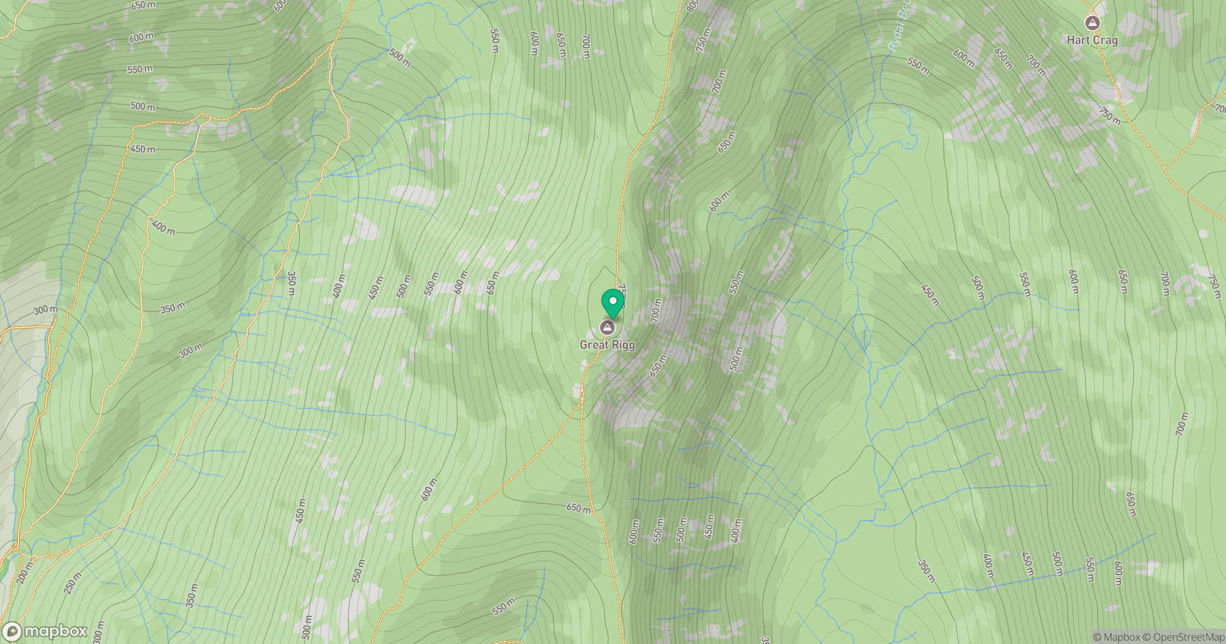
Grid reference: NY355104
View on OpenStreetMapOpens a map in a new tab, centred on the hill.
Hills within 30 km
Straight-line distance, not a walking route or confirmation of access.
No comments yet. Be the first.