

Claife Heights
Good walks are even better shared.
SD3897 : Walk around Claife Heights [62]
Michael Dibb Photo source
Overview
Claife Heights
Claife Heights rises to a modest elevation of 270 metres, but don’t let its height fool you; the views from the top are nothing short of majestic. Ideally suited for a half-day adventure, it's perfect for families, energetic dogs, and anyone who enjoys nature without the hassle of serious climbing.
Geology
As you wander up the paths, take a moment to appreciate the geology of the area. The sedimentary rocks that make up Claife Heights are remnants of ancient sea beds and offer a window into the Earth's past. If you’re a geology buff or just enjoy looking at interesting rocks, keep your eyes peeled for colourful lichens and the odd fossil basking in the sun.
Routes
There are a couple of notable routes to choose from:
- Claife Viewing Station Trail: This is the primary path, winding through scenic woodlands and meadows. Expect to take around 2.5 hours to complete the 5.5 km trail, with plenty of opportunities to snap a few photos of those postcard-perfect views.
- Windermere Lakeside Path: For an easier stroll, the lakeside path offers an easy-to-follow route perfect for families or those looking for a gentle saunter along the water’s edge.
Summit Features
When you reach the summit, you’ll be greeted by a rocky outcrop and a charming wooden bench. It’s the ideal spot to crack open a picnic and bask in the glow of your accomplishment—or just doze off amidst the tranquillity.
Terrain Type
The terrain features a mix of smooth forest paths and slightly rugged rocky areas, ensuring a varied hike that keeps you on your toes. Don’t rush; take your time and enjoy the stroll.
Views
High on Claife Heights, the panorama is extensive. Lake Windermere glistens below, framed by the rolling fells. On clear days, you might even spot the fabled peaks of the Langdale Pikes. Autumn months are magical here, showcasing a riot of colours, perfect for your Instagram feed.
Access
The nearest parking is conveniently located at the Claife Viewing Station. A small charge applies, but you’ll thank yourself for not dealing with roadside chaos. Public transport connects you to Windermere with reasonable frequency, making this a lovely car-free outing.
Facilities
Feeling peckish? The café at Claife Viewing Station serves delightful cakes and warming beverages, ensuring you have the energy for the return journey. Remember to take advantage of the public toilets before you head out—that cup of tea needs to find its way back through!
History
The etymology of 'Claife' could bring you to poetry; meaning ‘cliff’, it perfectly encapsulates the rugged nature of this hill. Claife Heights holds an esteemed place in Lake District history, once serving as an artists’ retreat during the 18th-century tourism boom, inspiring countless paintings and poems.
So, whether you’re a seasoned hiker or just fancy a leisurely afternoon, Claife Heights has something for everyone. Pack your favourite snacks, put on your walking shoes, and get ready for a stunning day outdoors!
Happy hiking!
Explore routes near Claife Heights
Walks starting near this hill. Open a route to check its map, distance and full itinerary.
Windermere west shore: Ash Landing to Wray and back
View route
Grizedale: Silurian Way walking trail
View route
Tarn Hows Fast Route
View route
Coniston to Tarn Hows: Monk Coniston Gardens and Woodland Circuit
View route
Route planning notes
These notes describe possible approaches. Check a route's map and access information when planning your walk.
Claife Viewing Station Trail
A picturesque route starting at the Claife Viewing Station offering splendid vistas of Windermere and the surrounding fells.
Windermere Lakeside Path
A scenic lakeside walk linking various viewpoints and picnic spots, suitable for families and casual walkers.
Make a day of it, together
Find someone to share the walk with, or organise a day out along a route you like.
Photo Gallery
View all Photo could not load
SD3897 : Walk around Claife Heights [62]
Michael Dibb
 Photo could not load
SD3897 : Waymarker in forest
Tom Richardson
 Photo could not load
SD3897 : Clearing of Bracken
DS Pugh
 Photo could not load
SD3897 : Walk around Claife Heights [51]
Michael Dibb
 Photo could not load
SD3897 : Walk around Claife Heights [47]
Michael Dibb
 Photo could not load
SD3897 : Walk around Claife Heights [48]
Michael Dibb
 Photo could not load
SD3897 : Approaching the Top
Michael Graham
 Photo could not load
SD3897 : High Blind How, Claife Heights (270m)
Karl and Ali
 Photo could not load
SD3897 : Trig point on High Blind How
Karl and Ali

SD3897 : Walk around Claife Heights [49]
Michael Dibb
Hill facts and local notes
Classifications
Elevation
270m
885 ft
Prominence
176m
Coordinates
54.3679, -2.9527
SD382973
OS Map
96 97
Explorer: OL7N
At the Summit
The summit is home to a small rocky outcrop with a charming wooden bench, perfect for a well-earned rest - if you can resist the temptation to nap!
Terrain & Geology
Claife Heights is primarily composed of sedimentary rocks, mainly limestone and sandstone, which can reveal fascinating fossils if you're lucky (or persistent). The landscape showcases the classic glacial features typical of the Lake District.
Views & Scenery
From the summit, you can marvel at the stunning views of Lake Windermere, the surrounding fells including the Langdale Pikes, and on a clear day, the distant peaks of the Eastern Fells.
History & Heritage
Name Origin
The name 'Claife' is believed to derive from the Old Norse 'kléfi', meaning ‘cliff’ or ‘rock’, reflecting the rugged terrain.
Historical Significance
Claife Heights has historical significance as a viewing point dating back to the 18th-century tourist boom in the Lake District, serving as a sanctuary for artists and poets alike.
Getting There & Facilities
Parking
There is a car park at the Claife Viewing Station, which charges a modest fee. Arrive early to snag a good spot, especially on weekends.
Public Transport
Regular bus services run from Windermere to the nearby village of Near and Claife Viewing Station, allowing for a convenient car-free approach.
Nearby Facilities
Nearby facilities include the Claife Viewing Station café, which offers delicious homemade cakes and hot drinks; public toilets are also available.
Safety Information
Known Hazards
- Slippery paths in wet weather, occasional loose rocks on steeper sections, and wildlife encounters (just say no to the wasps!).
General Safety Tips
- Check weather conditions before setting out
- Carry appropriate clothing and equipment
- Let someone know your planned route
- Take a map, compass, and GPS device
- Carry emergency supplies: food, water, first aid kit, torch
Hills
Some common questions about the hills answered
Are there group walks up Claife Heights?
Many walkers use Walkmates to join or organise walks with others. You can check for group walks around Claife Heights through the maps
Are there other walkers around Claife Heights?
Activity varies by location and time, but Walkmates lets you see whether others have shared walks or shown interest in this area. Find other people through the walking friends search walking friends for Claife Heights search or of course create your own walk for Claife Heights
Can I organise a walk to Claife Heights?
Yes. If there aren’t any walks listed already, you can create a walk and make it available for others to join.
If you're signed up to Walkmates, you can create a walk to Claife Heights.
How do I find a walk up this hill?
There are often multiple ways to walk this hill, depending on experience and route preference. Walkmates helps you explore walks and routes that others have shared.
Can I suggest a new route up Claife Heights?
Yes. You can suggest or create routes to share with others. Walkmates focuses on the social side of walking, so routes are used to help people organise walks and explore areas together, rather than as detailed navigation tools or route libraries.
Other uses really appreciate knowledgeable walkers sharing their routes. Share your favourite route to Claife Heights here
The is an error or something incorrect about this hill. How do I let you know?
We always strive to keep the information on Walkmates as accurate as possible. If you find an error, please let us know through the contact form and we'll aim to correct it as quickly as possible
Community Discussion
Comments
Location
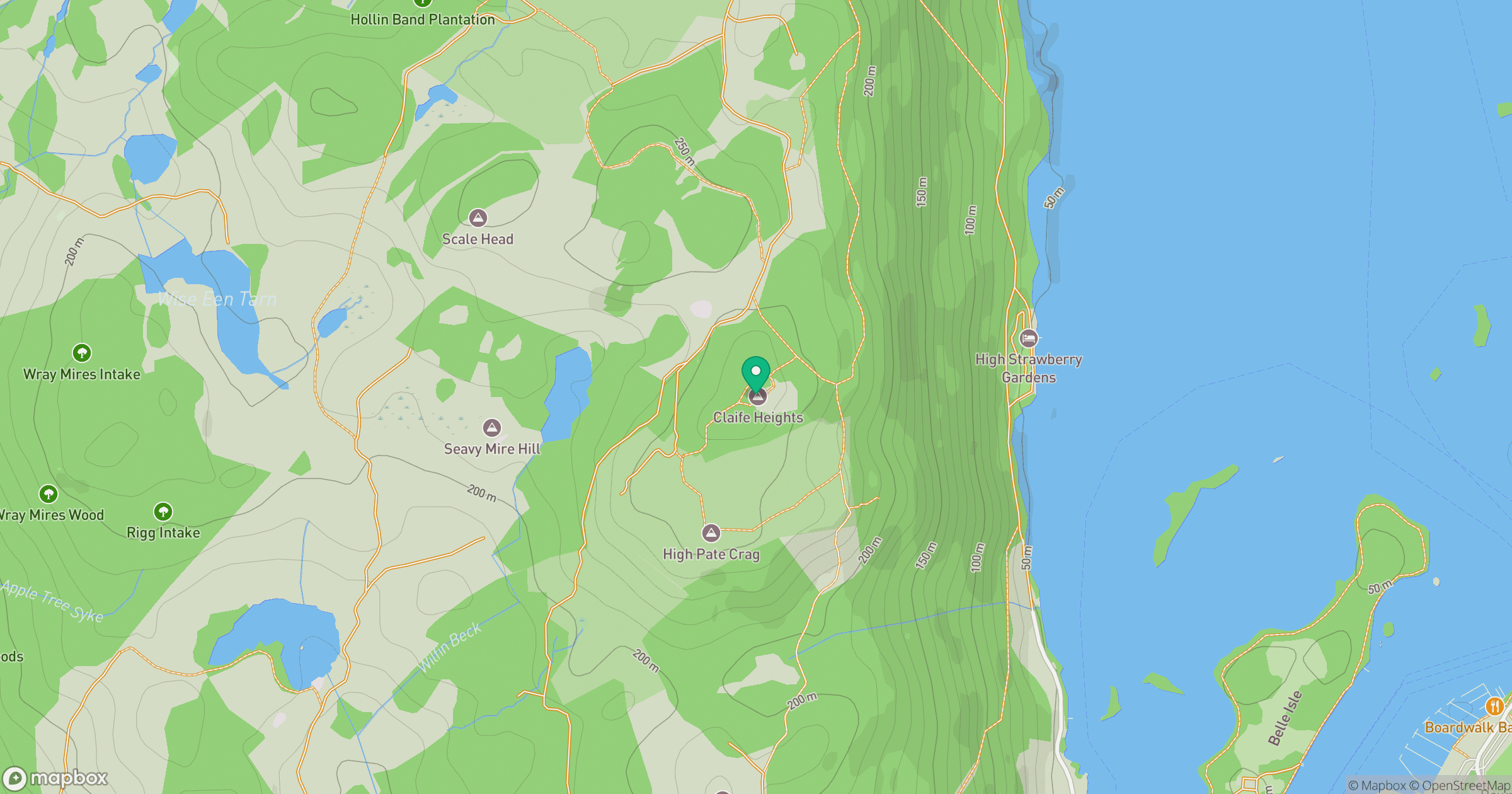
Grid reference: SD382973
View on OpenStreetMapOpens a map in a new tab, centred on the hill.
No comments yet. Be the first.